IMAGES TAKEN NEAR TO
Long Sandall, DONCASTER, DN2 4RA
Introduction
This page details the photographs taken nearby to DN2 4RA by members of the Geograph project.
The Geograph project started in 2005 with the aim of publishing, organising and preserving representative images for every square kilometre of Great Britain, Ireland and the Isle of Man.

There are currently over 7.5m images from over14,400 individuals and you can help contribute to the project by visiting https://www.geograph.org.uk
Image Map (Loading...)


Getting Data...Please wait
Leaflet Map data © OpenStreetMap
Images are licensed for reuse under creativecommons.org/licenses/by-sa/2.0
Notes
- Clicking on the map will re-center to the selected point.
- The higher the marker number, the further away the image location is from the centre of the postcode.
Image Listing (28 Images Found)
Images are licensed for reuse under creativecommons.org/licenses/by-sa/2.0
Image
Details
Distance
1
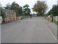
Private Level Crossing
This level crossing leads to a glass works just behind the gate to the left.
Image: © Michael Patterson
Taken: 16 Oct 2006
0.08 miles
2
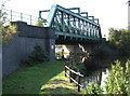
Long Sandall - railway bridge (northern)
This is the northern of the two railway bridges that cross the Don Navigation here. For a photo of the southern (disused) bridge, please see Image
Image: © Dave Bevis
Taken: 15 Sep 2011
0.08 miles
3
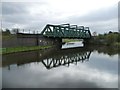
Long Sandall railway bridge
Seen from the barge Sobriety, on the River Dun Navigation, heading from Goole to Sprotbrough.
Image: © Christine Johnstone
Taken: 4 Apr 2014
0.08 miles
4
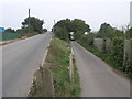
Two Roads and a Railway
The road to the left climbs over the railway, the one on the right leads to the railway for maintenance.
Image: © Michael Patterson
Taken: 16 Oct 2006
0.08 miles
5
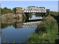
Long Sandall - railway bridge (southern)
This is the southern of the two railway bridges that cross the Don Navigation here. This southern one is no longer used by trains. For a photo of the northern bridge, please see Image
Image: © Dave Bevis
Taken: 15 Sep 2011
0.09 miles
6
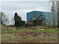
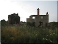
Derelict farmhouse, Poplar Farm, Clay Lane West
Seen from the barge Sobriety, heading from Goole to Sprotbrough.
Image: © Christine Johnstone
Taken: 4 Apr 2014
0.09 miles
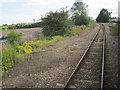
7
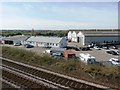
Railway and Industrial Estate at Long Sandall
Railway line between Kirk Sandall and Doncaster pictured from a road bridge (DOW/9) on Clay Lane. Beyond the industrial units is the flat landscape of Arksey Common.
Image: © Jonathan Clitheroe
Taken: 3 Apr 2017
0.13 miles
8
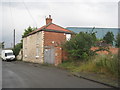
Stone faced cottage
Isolated in an industrial area. The other houses in the immediate vicinity are derelict but this one carries on.
Image: © Jonathan Thacker
Taken: 6 Aug 2011
0.13 miles
9
Ruined cottages
This is an industrial area and most of the houses are now ruined.
Image: © Jonathan Thacker
Taken: 6 Aug 2011
0.13 miles
10
The 'South Yorkshire Joint Railway' line near Kirk Sandall
This freight line runs through South Yorkshire to Dinnington and Shireoaks.
Seen from an excursion train.
Image: © Nigel Thompson
Taken: 13 Jul 2014
0.14 miles