IMAGES TAKEN NEAR TO
Worcester Avenue, DONCASTER, DN2 4NB
Introduction
This page details the photographs taken nearby to Worcester Avenue, DN2 4NB by members of the Geograph project.
The Geograph project started in 2005 with the aim of publishing, organising and preserving representative images for every square kilometre of Great Britain, Ireland and the Isle of Man.

There are currently over 7.5m images from over14,400 individuals and you can help contribute to the project by visiting https://www.geograph.org.uk
Image Map
Images are licensed for reuse under creativecommons.org/licenses/by-sa/2.0
Notes
- Clicking on the map will re-center to the selected point.
- The higher the marker number, the further away the image location is from the centre of the postcode.
Image Listing (6 Images Found)
Images are licensed for reuse under creativecommons.org/licenses/by-sa/2.0
Image
Details
Distance
1

Traffic Lights onto Wheatley Hall Road
Image: © Steve Fareham
Taken: 21 Feb 2008
0.15 miles
3
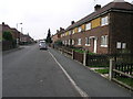
Rows and Rows of Houses
Wheatley Park estate consists of hundreds of houses built in terraces as here as well as semi-detached.
Image: © Michael Patterson
Taken: 16 Oct 2006
0.20 miles
5
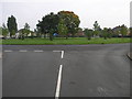
Estate Island
This island in the middle of Wheatley Park housing estate has six roads leading off it.
Image: © Michael Patterson
Taken: 16 Oct 2006
0.21 miles
