IMAGES TAKEN NEAR TO
Gosford Road, DONCASTER, DN2 4FH
Introduction
This page details the photographs taken nearby to Gosford Road, DN2 4FH by members of the Geograph project.
The Geograph project started in 2005 with the aim of publishing, organising and preserving representative images for every square kilometre of Great Britain, Ireland and the Isle of Man.

There are currently over 7.5m images from over14,400 individuals and you can help contribute to the project by visiting https://www.geograph.org.uk
Image Map
Images are licensed for reuse under creativecommons.org/licenses/by-sa/2.0
Notes
- Clicking on the map will re-center to the selected point.
- The higher the marker number, the further away the image location is from the centre of the postcode.
Image Listing (8 Images Found)
Images are licensed for reuse under creativecommons.org/licenses/by-sa/2.0
Image
Details
Distance
2
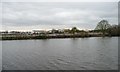
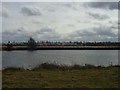
Former wharf, former industrial site, Wheatley Park
On the south bank of Wheatley Cut. Seen from the barge Sobriety, heading from Goole to Sprotbrough.
Image: © Christine Johnstone
Taken: 4 Apr 2014
0.15 miles

4
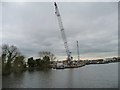
Land-based crane, south bank, Wheatley Cut
Used to load steel piles before they are taken across the canal, to the bank strengthening works on the north bank. Seen from the barge Sobriety, heading from Goole to Sprotbrough.
Image: © Christine Johnstone
Taken: 4 Apr 2014
0.19 miles
5

Traffic Lights onto Wheatley Hall Road
Image: © Steve Fareham
Taken: 21 Feb 2008
0.19 miles
6
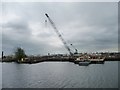
Crane on a pontoon, south bank, Wheatley Cut
Used to transport steel piles across the canal, to the bank strengthening works on the north bank. Seen from the barge Sobriety, heading from Goole to Sprotbrough.
Image: © Christine Johnstone
Taken: 4 Apr 2014
0.21 miles
7
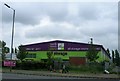
Looking across the canal to the shops at the Wheatley centre.
The buildings on the map have since been demolished.
Image: © steven ruffles
Taken: 15 Mar 2010
0.23 miles
8
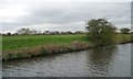
Flood bank between the navigable and unnavigable River Dons
Seen from the barge Sobriety, heading from Goole to Sprotbrough.
Image: © Christine Johnstone
Taken: 4 Apr 2014
0.24 miles