IMAGES TAKEN NEAR TO
Woodhouse Road, DONCASTER, DN2 4DG
Introduction
This page details the photographs taken nearby to Woodhouse Road, DN2 4DG by members of the Geograph project.
The Geograph project started in 2005 with the aim of publishing, organising and preserving representative images for every square kilometre of Great Britain, Ireland and the Isle of Man.

There are currently over 7.5m images from over14,400 individuals and you can help contribute to the project by visiting https://www.geograph.org.uk
Image Map (Loading...)


Getting Data...Please wait
Leaflet Map data © OpenStreetMap
Images are licensed for reuse under creativecommons.org/licenses/by-sa/2.0
Notes
- Clicking on the map will re-center to the selected point.
- The higher the marker number, the further away the image location is from the centre of the postcode.
Image Listing (7 Images Found)
Images are licensed for reuse under creativecommons.org/licenses/by-sa/2.0
Image
Details
Distance
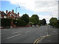
1
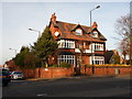
Wentworth Road in Doncaster
Looking towards the suburb of Wheatley from a crossroads close to the hospital.
Image: © Jonathan Clitheroe
Taken: 19 Feb 2017
0.16 miles
2
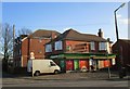
Norborough Road, Doncaster
Off Thorne Road.
Image: © Richard Vince
Taken: 26 Jun 2021
0.20 miles
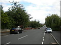
3
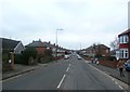
Thorne Road, Doncaster
Seen at its junction with Norborough Road (left) and Zetland Road (right).
Image: © Richard Vince
Taken: 26 Jun 2021
0.22 miles
5
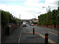
Zetland Road, Doncaster
Seen from close to its junction with Thorne Road.
Image: © Richard Vince
Taken: 26 Jun 2021
0.24 miles