IMAGES TAKEN NEAR TO
St. Helens Rise, RETFORD, DN22 9DN
Introduction
This page details the photographs taken nearby to St. Helens Rise, DN22 9DN by members of the Geograph project.
The Geograph project started in 2005 with the aim of publishing, organising and preserving representative images for every square kilometre of Great Britain, Ireland and the Isle of Man.

There are currently over 7.5m images from over14,400 individuals and you can help contribute to the project by visiting https://www.geograph.org.uk
Image Map
Images are licensed for reuse under creativecommons.org/licenses/by-sa/2.0
Notes
- Clicking on the map will re-center to the selected point.
- The higher the marker number, the further away the image location is from the centre of the postcode.
Image Listing (32 Images Found)
Images are licensed for reuse under creativecommons.org/licenses/by-sa/2.0
Image
Details
Distance
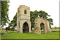
1
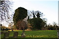
St.Helen's church, South Wheatley
Ruinous since 1883, all that remains is the tower and the chancel arch.
Image: © Richard Croft
Taken: 15 Nov 2005
0.01 miles
2
The ruins of St. Helen's church, South Wheatley
All that remains are the tower and the Norman chancel arch http://www.britishlistedbuildings.co.uk/en-411344-remains-of-church-of-st-helen-south-whea
Image: © Jonathan Thacker
Taken: 19 Oct 2012
0.03 miles
3
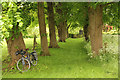
Church path
Avenue of trees flanking the footpath that once led from the south door of St.Helen's church http://www.geograph.org.uk/photo/4974345
Image: © Richard Croft
Taken: 30 May 2016
0.03 miles
4

Ruins of St Helen's Church, South Wheatley
The parish church was abandoned in 1883 when the parishes of North and South Wheatley were amalgamated. Ten years ago the ruins of St Helen's were rather neglected as ivy threatened both remaining structures. See Richard Croft's 2005 photograph:- http://www.geograph.org.uk/photo/78983
Image: © Neil Theasby
Taken: 8 Feb 2015
0.03 miles
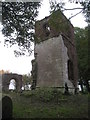
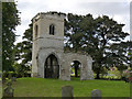
6
St.Helen's church ruins
Tower and chancel arch of St.Helen's church, stripped of the ivy covering when I visited in 2005 http://www.geograph.org.uk/photo/78983
Abandoned in 1883 when the parishes of North and South Wheatley combined
Image: © Richard Croft
Taken: 30 May 2016
0.03 miles
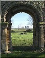
7
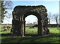
View to West Burton Power Station
Through the ruined chancel arch of St Helen's Church, South Wheatley - a Grade I listed structure.
Image: © Neil Theasby
Taken: 8 Feb 2015
0.03 miles
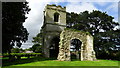
8
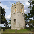
Remains of St Helen's Church, South Wheatley
The tower stands proud without its previous coat of ivy.
Image: © Alan Murray-Rust
Taken: 28 Sep 2014
0.03 miles
9
Remains of St Helen's Church, South Wheatley
View from the south east.
Image: © Alan Murray-Rust
Taken: 28 Sep 2014
0.03 miles
10
Chancel arch, St Helen's, South Wheatley
With a view to West Burton Power Station.
St Helen's Church was largely abandoned in 1883 when the parishes of North and South Wheatley combined. Recent restorative works have provided the Norman arch and the old church tower with a new lease of life.
Image: © Neil Theasby
Taken: 8 Feb 2015
0.04 miles