IMAGES TAKEN NEAR TO
Sutton, RETFORD, DN22 8SB
Introduction
This page details the photographs taken nearby to DN22 8SB by members of the Geograph project.
The Geograph project started in 2005 with the aim of publishing, organising and preserving representative images for every square kilometre of Great Britain, Ireland and the Isle of Man.

There are currently over 7.5m images from over14,400 individuals and you can help contribute to the project by visiting https://www.geograph.org.uk
Image Map (Loading...)


Getting Data...Please wait
Leaflet Map data © OpenStreetMap
Images are licensed for reuse under creativecommons.org/licenses/by-sa/2.0
Notes
- Clicking on the map will re-center to the selected point.
- The higher the marker number, the further away the image location is from the centre of the postcode.
Image Listing (6 Images Found)
Images are licensed for reuse under creativecommons.org/licenses/by-sa/2.0
Image
Details
Distance
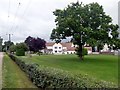
1
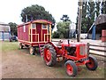
At Low Farm near Sutton Grange
An old showman's caravan has been preserved along with an old Nuffield 60 tractor.
Image: © Neil Theasby
Taken: 23 Aug 2013
0.02 miles
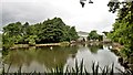
3
Lound Low Road Byway
Near the wildfowl reserve.
Image: © Steve Fareham
Taken: 16 Jul 2010
0.04 miles
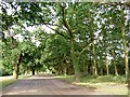
5
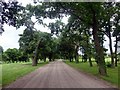
Lound Low Road
Wide, tree-lined and with a decent surface - all most unusual for a byway
Image: © Graham Hogg
Taken: 12 Jun 2018
0.10 miles