IMAGES TAKEN NEAR TO
Highfield Farm Courtyard, Little Top Lane, RETFORD, DN22 8RE
Introduction
This page details the photographs taken nearby to Highfield Farm Courtyard, Little Top Lane, DN22 8RE by members of the Geograph project.
The Geograph project started in 2005 with the aim of publishing, organising and preserving representative images for every square kilometre of Great Britain, Ireland and the Isle of Man.

There are currently over 7.5m images from over14,400 individuals and you can help contribute to the project by visiting https://www.geograph.org.uk
Image Map
Images are licensed for reuse under creativecommons.org/licenses/by-sa/2.0
Notes
- Clicking on the map will re-center to the selected point.
- The higher the marker number, the further away the image location is from the centre of the postcode.
Image Listing (30 Images Found)
Images are licensed for reuse under creativecommons.org/licenses/by-sa/2.0
Image
Details
Distance
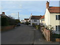
1
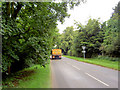
Lots of heavy traffic trundle through this village from the quarries.
Image: © Steve Fareham
Taken: 15 Aug 2007
0.10 miles
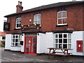
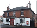
3
The Bluebell inn, Lound.
Pub on Town street.
Image: © steven ruffles
Taken: 18 Mar 2023
0.12 miles
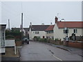
5
Town Street, Lound
The main street of the village, looking north from the Bell Inn.
Image: © Alan Murray-Rust
Taken: 31 Mar 2011
0.12 miles
7
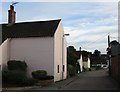
Town Street, Lound
The older properties are all gable end to the street.
Image: © Jonathan Thacker
Taken: 21 Aug 2016
0.12 miles
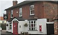
8
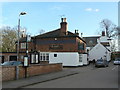
The Bluebell Inn, Lound
The village pub, seen from the north.
Image: © Alan Murray-Rust
Taken: 31 Mar 2011
0.12 miles
9
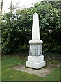
Lound War Memorial
A plain obelisk which lists all from the village who served and survived in the 1914-19 war, as well as those who died.
Image: © Alan Murray-Rust
Taken: 31 Mar 2011
0.13 miles
10
Start of Neatholme Lane.
This carries on as along straight bridleway all the way to the River Idle.
Image: © Steve Fareham
Taken: 15 Aug 2007
0.13 miles