IMAGES TAKEN NEAR TO
St. Martins Bungalows, RETFORD, DN22 8HY
Introduction
This page details the photographs taken nearby to St. Martins Bungalows, DN22 8HY by members of the Geograph project.
The Geograph project started in 2005 with the aim of publishing, organising and preserving representative images for every square kilometre of Great Britain, Ireland and the Isle of Man.

There are currently over 7.5m images from over14,400 individuals and you can help contribute to the project by visiting https://www.geograph.org.uk
Image Map
Images are licensed for reuse under creativecommons.org/licenses/by-sa/2.0
Notes
- Clicking on the map will re-center to the selected point.
- The higher the marker number, the further away the image location is from the centre of the postcode.
Image Listing (103 Images Found)
Images are licensed for reuse under creativecommons.org/licenses/by-sa/2.0
Image
Details
Distance
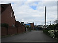
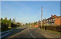
1
New years day Ranby village
Looking towards the chesterfield canal the road bridge over the canal is seen in the distance.
Image: © roger geach
Taken: 1 Jan 2010
0.02 miles
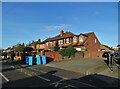
2
Back of bungalows on Blyth Road, beside the Chesterfield Canal, Ranby
Image: © Chris Morgan
Taken: 3 Sep 2012
0.02 miles
5
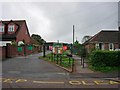
Ranby Primary School - school entrance
On Blyth Road, Ranby
Image: © Neil Theasby
Taken: 1 Dec 2020
0.03 miles
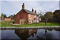
6
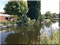
Cottage next to the Chesterfield Canal, Ranby
Image: © Mat Fascione
Taken: 22 May 2016
0.03 miles
7
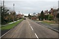
Blyth Road Ranby
With the entrance to the primary school on the right.
Image: © Steve Fareham
Taken: 6 Jan 2009
0.03 miles
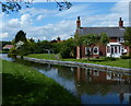
8
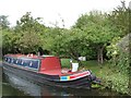
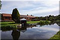
Narrowboat moored alongside small orchard
On the Chesterfield Canal at Ranby.
Image: © Christine Johnstone
Taken: 13 Oct 2011
0.04 miles