IMAGES TAKEN NEAR TO
Dover Bottom, RETFORD, DN22 8DA
Introduction
This page details the photographs taken nearby to Dover Bottom, DN22 8DA by members of the Geograph project.
The Geograph project started in 2005 with the aim of publishing, organising and preserving representative images for every square kilometre of Great Britain, Ireland and the Isle of Man.

There are currently over 7.5m images from over14,400 individuals and you can help contribute to the project by visiting https://www.geograph.org.uk
Image Map
Images are licensed for reuse under creativecommons.org/licenses/by-sa/2.0
Notes
- Clicking on the map will re-center to the selected point.
- The higher the marker number, the further away the image location is from the centre of the postcode.
Image Listing (3 Images Found)
Images are licensed for reuse under creativecommons.org/licenses/by-sa/2.0
Image
Details
Distance
1
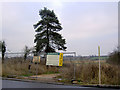
Residential development land for sale
Opposite Gamston airport.
Image: © Steve Fareham
Taken: 18 Dec 2007
0.02 miles
2
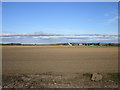
Gamston (Retford) Airport
Seen from what was the perimeter road when this opened as RAF Gamston in 1942. It is now a small commercial airport.
Image: © Jonathan Thacker
Taken: 25 Oct 2018
0.14 miles
3
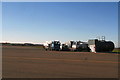
Refuelling equipment at Retford (Gamston) Airport
Image: © Chris
Taken: 11 Mar 2014
0.25 miles