IMAGES TAKEN NEAR TO
Black Hereford Way, RETFORD, DN22 7ZQ
Introduction
This page details the photographs taken nearby to Black Hereford Way, DN22 7ZQ by members of the Geograph project.
The Geograph project started in 2005 with the aim of publishing, organising and preserving representative images for every square kilometre of Great Britain, Ireland and the Isle of Man.

There are currently over 7.5m images from over14,400 individuals and you can help contribute to the project by visiting https://www.geograph.org.uk
Image Map
Images are licensed for reuse under creativecommons.org/licenses/by-sa/2.0
Notes
- Clicking on the map will re-center to the selected point.
- The higher the marker number, the further away the image location is from the centre of the postcode.
Image Listing (5 Images Found)
Images are licensed for reuse under creativecommons.org/licenses/by-sa/2.0
Image
Details
Distance
2
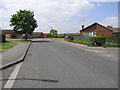
Newlands
Situated close to the Lincoln-Sheffield railway line Newlands makes up the half of this square which is housing. The other half being a golf course.
Image: © Michael Patterson
Taken: 2 Jun 2006
0.22 miles
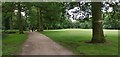
3
A corner of Retford golf course near the club house
A view from the start of the footpath continuing west from the end of Brecks Road.
Image: © Andrew Hill
Taken: 28 May 2010
0.22 miles
4
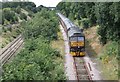
Special Charter train.
47245 is seen on the link line from the low level to the high level railway at Retford on a special charter train around Notts and Yorks this past Saturday.
Image: © roger geach
Taken: 2 Aug 2008
0.25 miles
5
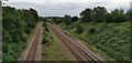
Links from Retford lower lines to East Coast Mainline
Image: © Chris Morgan
Taken: 13 Jul 2020
0.25 miles