IMAGES TAKEN NEAR TO
Long Walk, RETFORD, DN22 7YX
Introduction
This page details the photographs taken nearby to Long Walk, DN22 7YX by members of the Geograph project.
The Geograph project started in 2005 with the aim of publishing, organising and preserving representative images for every square kilometre of Great Britain, Ireland and the Isle of Man.

There are currently over 7.5m images from over14,400 individuals and you can help contribute to the project by visiting https://www.geograph.org.uk
Image Map (Loading...)


Getting Data...Please wait
Leaflet Map data © OpenStreetMap
Images are licensed for reuse under creativecommons.org/licenses/by-sa/2.0
Notes
- Clicking on the map will re-center to the selected point.
- The higher the marker number, the further away the image location is from the centre of the postcode.
Image Listing (18 Images Found)
Images are licensed for reuse under creativecommons.org/licenses/by-sa/2.0
Image
Details
Distance
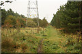
3
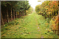
Babworth Woods
Path through Babworth Woods, private woodland with permissive access
Image: © Richard Croft
Taken: 19 Oct 2012
0.13 miles
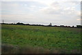
5
Babworth Woods
Private woodland with permissive access
Image: © Richard Croft
Taken: 19 Oct 2012
0.14 miles
7
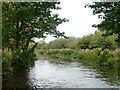
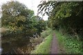
The Chesterfield Canal
Between bridges 54 and 54a, on the western edge of Retford.
Image: © Christine Johnstone
Taken: 13 Oct 2011
0.18 miles