IMAGES TAKEN NEAR TO
St. Andrews Way, RETFORD, DN22 7WU
Introduction
This page details the photographs taken nearby to St. Andrews Way, DN22 7WU by members of the Geograph project.
The Geograph project started in 2005 with the aim of publishing, organising and preserving representative images for every square kilometre of Great Britain, Ireland and the Isle of Man.

There are currently over 7.5m images from over14,400 individuals and you can help contribute to the project by visiting https://www.geograph.org.uk
Image Map (Loading...)


Getting Data...Please wait
Leaflet Map data © OpenStreetMap
Images are licensed for reuse under creativecommons.org/licenses/by-sa/2.0
Notes
- Clicking on the map will re-center to the selected point.
- The higher the marker number, the further away the image location is from the centre of the postcode.
Image Listing (8 Images Found)
Images are licensed for reuse under creativecommons.org/licenses/by-sa/2.0
Image
Details
Distance
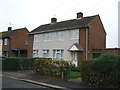
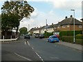
3
Lockwood Drive, Ordsall
A residential side street between West Hill Road and Retford golf course.
Image: © Andrew Hill
Taken: 28 May 2010
0.17 miles
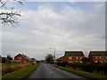
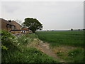
4
Brecks Road
Post-war housing development in the Retford suburb of Ordsall.
Image: © Alan Murray-Rust
Taken: 11 Oct 2015
0.20 miles
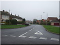
5
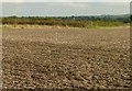
Field footpath
Footprints have started to appear since the field was prepared for its next crop.
Image: © Alan Murray-Rust
Taken: 11 Oct 2015
0.20 miles
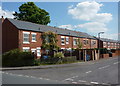
7
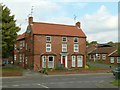
The Grange, Ordsall
Early 19th century farmhouse. The bay windows are a later addition. Listed Grade II. The current listing refers to a stable range to the left of the house, but this had clearly been demolished by the early 1990s.
Image: © Alan Murray-Rust
Taken: 11 Oct 2015
0.23 miles