IMAGES TAKEN NEAR TO
Farm View, RETFORD, DN22 7UT
Introduction
This page details the photographs taken nearby to Farm View, DN22 7UT by members of the Geograph project.
The Geograph project started in 2005 with the aim of publishing, organising and preserving representative images for every square kilometre of Great Britain, Ireland and the Isle of Man.

There are currently over 7.5m images from over14,400 individuals and you can help contribute to the project by visiting https://www.geograph.org.uk
Image Map (51 Images)


Getting Data...Please wait
Leaflet Map data © OpenStreetMap
Images are licensed for reuse under creativecommons.org/licenses/by-sa/2.0
Notes
- Clicking on the map will re-center to the selected point.
- The higher the marker number, the further away the image location is from the centre of the postcode.
Image Listing (51 Images Found)
Images are licensed for reuse under creativecommons.org/licenses/by-sa/2.0
Image
Details
Distance
1
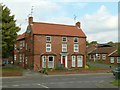
The Grange, Ordsall
Early 19th century farmhouse. The bay windows are a later addition. Listed Grade II. The current listing refers to a stable range to the left of the house, but this had clearly been demolished by the early 1990s.
Image: © Alan Murray-Rust
Taken: 11 Oct 2015
0.04 miles
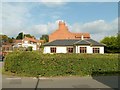
2
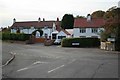
The Plough Inn, Ordsall
Despite the continued presence the inn sign, the pub closed several years previously and was being rebuilt as a private residence.
Image: © Alan Murray-Rust
Taken: 11 Oct 2015
0.12 miles
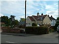
3
The Old School Hall
Mid 19th century village school, now a private house.
Image: © Alan Murray-Rust
Taken: 11 Oct 2015
0.15 miles
5
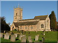
All Hallows Church Ordsall Nr Retford
A beautiful 13th. Century Village church, situated on a hill above the River Idle. John S Piercy who, in 1828, wrote "A History of Retford" is buried in the churchyard.
Image: © B Hilton
Taken: 4 Nov 2005
0.16 miles
7
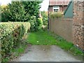
Hill Street, Ordsall
Shown as a road on OS maps, but reduced now to a footpath.
Image: © Alan Murray-Rust
Taken: 11 Oct 2015
0.18 miles
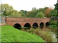
9
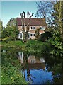
Goosemoor Lane Bridge, Ordsall
It spans The River Idle
Image: © Neil Theasby
Taken: 22 Oct 2020
0.18 miles
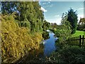
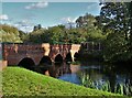
10
Goosemoor Lane Bridge
An attractive 5 span brick bridge crossing the River Idle.
Image: © Alan Murray-Rust
Taken: 11 Oct 2015
0.19 miles