IMAGES TAKEN NEAR TO
St. Helens Road, RETFORD, DN22 7HA
Introduction
This page details the photographs taken nearby to St. Helens Road, DN22 7HA by members of the Geograph project.
The Geograph project started in 2005 with the aim of publishing, organising and preserving representative images for every square kilometre of Great Britain, Ireland and the Isle of Man.

There are currently over 7.5m images from over14,400 individuals and you can help contribute to the project by visiting https://www.geograph.org.uk
Image Map
Images are licensed for reuse under creativecommons.org/licenses/by-sa/2.0
Notes
- Clicking on the map will re-center to the selected point.
- The higher the marker number, the further away the image location is from the centre of the postcode.
Image Listing (14 Images Found)
Images are licensed for reuse under creativecommons.org/licenses/by-sa/2.0
Image
Details
Distance
1
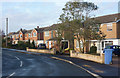
Houses on Grove Coach Road
At the east edge of the built up area, looking towards London road and the town.
Image: © Andrew Hill
Taken: 28 Dec 2009
0.06 miles

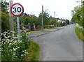
5
Looking along Grove Coach Road
East of the housing estate the road becomes a track with vehicular access to a few houses and farms. It was very icy after a long cold spell.
Image: © Andrew Hill
Taken: 28 Dec 2009
0.14 miles
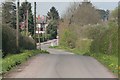
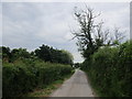
9
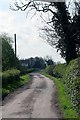
Lane by Walmoor Farm
A restricted byway.
Image: © Jonathan Thacker
Taken: 13 Jun 2014
0.19 miles
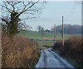
10
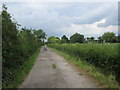
Lane by Walmoor Farm
A restricted byway.
Image: © Jonathan Thacker
Taken: 13 Jun 2014
0.20 miles