IMAGES TAKEN NEAR TO
Westbourne Close, RETFORD, DN22 7ES
Introduction
This page details the photographs taken nearby to Westbourne Close, DN22 7ES by members of the Geograph project.
The Geograph project started in 2005 with the aim of publishing, organising and preserving representative images for every square kilometre of Great Britain, Ireland and the Isle of Man.

There are currently over 7.5m images from over14,400 individuals and you can help contribute to the project by visiting https://www.geograph.org.uk
Image Map (Loading...)


Getting Data...Please wait
Leaflet Map data © OpenStreetMap
Images are licensed for reuse under creativecommons.org/licenses/by-sa/2.0
Notes
- Clicking on the map will re-center to the selected point.
- The higher the marker number, the further away the image location is from the centre of the postcode.
Image Listing (45 Images Found)
Images are licensed for reuse under creativecommons.org/licenses/by-sa/2.0
Image
Details
Distance
1
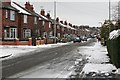
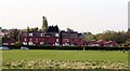
Trent Street in the snow
Pennington Walk on the left, looking down Trent Street.
Image: © roger geach
Taken: 20 Jan 2013
0.09 miles
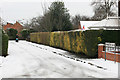
3
Garden in Wharton Street
The houses in Wharton Street are interspersed with several gaps like the one pictured which currently contains some interesting vehicles.
Image: © Paul Collins
Taken: 29 Jul 2018
0.12 miles
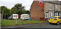
5
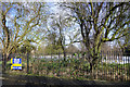
Former school land for sale
This was the site of Retford Oaks High School which has moved to new buildings on the other side of town. The land here is now available for residential development.
Image: © Bill Boaden
Taken: 30 Jan 2015
0.15 miles
6
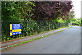
School site for sale
Former school site for sale with outline planning permission for residential development.
Image: © David Martin
Taken: 28 Jun 2014
0.16 miles
7
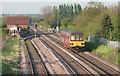
Approaching Retford
The Lincoln to Sheffield service is seen approaching Gringley, Retford on a summer's evening.
Image: © roger geach
Taken: 6 May 2008
0.16 miles
8
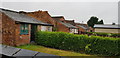
Outhouses in Caledonian Road
It is nice to see such a set of unmolested outhouses. They are at the end of the gardens of houses in Caledonian Road and are viewed from the twitten that joins that road with Storcroft Road.
Image: © Paul Collins
Taken: 29 Jul 2018
0.16 miles
9
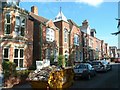
Holly Villa in Holly Road
Designed by local architect R Bertram Ogle, this stands out from a number of well built villas on the road. It is dated 1893 in terracotta panels in the central tower http://www.geograph.org.uk/photo/4699262. Not listed but of local importance. Currently occupied by a day nursery.
Image: © Alan Murray-Rust
Taken: 11 Oct 2015
0.17 miles