IMAGES TAKEN NEAR TO
Hospital Road, RETFORD, DN22 7BG
Introduction
This page details the photographs taken nearby to Hospital Road, DN22 7BG by members of the Geograph project.
The Geograph project started in 2005 with the aim of publishing, organising and preserving representative images for every square kilometre of Great Britain, Ireland and the Isle of Man.

There are currently over 7.5m images from over14,400 individuals and you can help contribute to the project by visiting https://www.geograph.org.uk
Image Map (Loading...)


Getting Data...Please wait
Leaflet Map data © OpenStreetMap
Images are licensed for reuse under creativecommons.org/licenses/by-sa/2.0
Notes
- Clicking on the map will re-center to the selected point.
- The higher the marker number, the further away the image location is from the centre of the postcode.
Image Listing (153 Images Found)
Images are licensed for reuse under creativecommons.org/licenses/by-sa/2.0
Image
Details
Distance
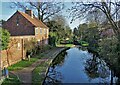
1
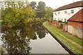
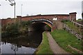
Chesterfield Canal
The Chesterfield Canal and Hannam's Yard from Babworth Road Bridge
Image: © Richard Croft
Taken: 19 Oct 2012
0.01 miles
4
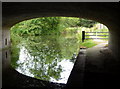
View from the canal road bridge
Looking out from underneath the bridge carrying the A620 to Retford.
Image: © Andrew Hill
Taken: 14 Jul 2010
0.02 miles

7
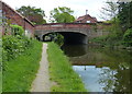
Hospital Road Bridge No 55
Crossing the Chesterfield Canal and Cuckoo Way in Retford.
Image: © Mat Fascione
Taken: 22 May 2016
0.03 miles
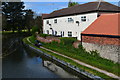
9
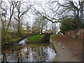
West Retford lock.
The Chesterfield canal.
Image: © steven ruffles
Taken: 18 Nov 2011
0.05 miles
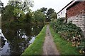
10
Chesterfield Canal seen from Babworth Road Bridge
Looking to West Retford Lock
Image: © Neil Theasby
Taken: 1 Dec 2020
0.05 miles