IMAGES TAKEN NEAR TO
Tiln Lane, RETFORD, DN22 6SW
Introduction
This page details the photographs taken nearby to Tiln Lane, DN22 6SW by members of the Geograph project.
The Geograph project started in 2005 with the aim of publishing, organising and preserving representative images for every square kilometre of Great Britain, Ireland and the Isle of Man.

There are currently over 7.5m images from over14,400 individuals and you can help contribute to the project by visiting https://www.geograph.org.uk
Image Map
Images are licensed for reuse under creativecommons.org/licenses/by-sa/2.0
Notes
- Clicking on the map will re-center to the selected point.
- The higher the marker number, the further away the image location is from the centre of the postcode.
Image Listing (7 Images Found)
Images are licensed for reuse under creativecommons.org/licenses/by-sa/2.0
Image
Details
Distance
3
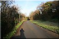
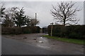
Bolham road
Narrow road to Bolham. Remains of some frost on the grass.
Image: © roger geach
Taken: 1 Dec 2009
0.17 miles
4
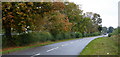
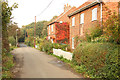
Tiln Lane approaching Retford
Signs of autumn now in the trees by the road. It is an alternative route from Gainsborough avoiding a low bridge on the A620.
Image: © Andrew Hill
Taken: 29 Sep 2010
0.20 miles
7
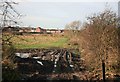
Hidden River
The river idle is out of view between the waste land and the housing estate.
Image: © roger geach
Taken: 1 Dec 2009
0.25 miles