IMAGES TAKEN NEAR TO
The Croft, RETFORD, DN22 6RQ
Introduction
This page details the photographs taken nearby to The Croft, DN22 6RQ by members of the Geograph project.
The Geograph project started in 2005 with the aim of publishing, organising and preserving representative images for every square kilometre of Great Britain, Ireland and the Isle of Man.

There are currently over 7.5m images from over14,400 individuals and you can help contribute to the project by visiting https://www.geograph.org.uk
Image Map (Loading...)


Getting Data...Please wait
Leaflet Map data © OpenStreetMap
Images are licensed for reuse under creativecommons.org/licenses/by-sa/2.0
Notes
- Clicking on the map will re-center to the selected point.
- The higher the marker number, the further away the image location is from the centre of the postcode.
Image Listing (82 Images Found)
Images are licensed for reuse under creativecommons.org/licenses/by-sa/2.0
Image
Details
Distance
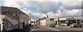
6
Moorgate, Retford
The main road (the A620) from Gainsborough heading towards the town centre of Retford.
Image: © Andrew Hill
Taken: 29 Sep 2010
0.10 miles
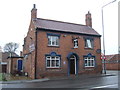
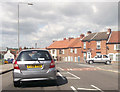
7
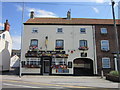
The Black Boy Pub
As seen from the other side of the road.
Image: © roger geach
Taken: 28 Nov 2010
0.13 miles
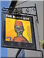
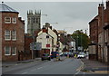
9
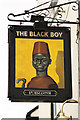
The sign of The Black Boy
Pub sign for The Black Boy at Retford http://www.geograph.org.uk/photo/1745432
Image: © Richard Croft
Taken: 9 Mar 2010
0.13 miles