IMAGES TAKEN NEAR TO
Thrumpton Lane, RETFORD, DN22 6HQ
Introduction
This page details the photographs taken nearby to Thrumpton Lane, DN22 6HQ by members of the Geograph project.
The Geograph project started in 2005 with the aim of publishing, organising and preserving representative images for every square kilometre of Great Britain, Ireland and the Isle of Man.

There are currently over 7.5m images from over14,400 individuals and you can help contribute to the project by visiting https://www.geograph.org.uk
Image Map (Loading...)


Getting Data...Please wait
Leaflet Map data © OpenStreetMap
Images are licensed for reuse under creativecommons.org/licenses/by-sa/2.0
Notes
- Clicking on the map will re-center to the selected point.
- The higher the marker number, the further away the image location is from the centre of the postcode.
Image Listing (136 Images Found)
Images are licensed for reuse under creativecommons.org/licenses/by-sa/2.0
Image
Details
Distance
1
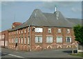
Former maltings, Thrumpton Lane
Now part of Icon Polymers (Northern Rubber Co.), the roof makes the original purpose of the building very clear.
There is a bench mark http://www.geograph.org.uk/photo/4699224 towards the far end of the maltings building.
Image: © Alan Murray-Rust
Taken: 11 Oct 2015
0.01 miles
2
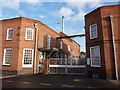
Factory gates, Thrumpton Lane
Factory entrance in Retford. This is the home of the Icon Polymer Group.
Image: © Andrew Hill
Taken: 28 Dec 2009
0.01 miles
3
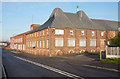
Factory on Thrumpton Lane
Just north of the railway, this factory complex is the Icon Polymer Group.
Image: © Andrew Hill
Taken: 28 Dec 2009
0.01 miles
4

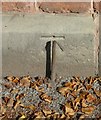
Bench mark, Icon Polymers, Thrumpton Lane
On the old maltings building. See http://www.geograph.org.uk/photo/4699197 for location.
Image: © Alan Murray-Rust
Taken: 11 Oct 2015
0.01 miles
5
Bench mark outside King Edward VI School
See http://www.geograph.org.uk/photo/4699237 for location. The steel peg looks as if it has been put in to form a base for surveying staffs when surveying from this mark.
Image: © Alan Murray-Rust
Taken: 11 Oct 2015
0.01 miles
6

Holly Villa in Holly Road (detail)
Designed by local architect R Bertram Ogle, this stands out from a number of well built villas on the road http://www.geograph.org.uk/photo/4699257. It is dated 1893 in terracotta panels in the central tower. Not listed but of local importance. Currently occupied by a day nursery.
Image: © Alan Murray-Rust
Taken: 11 Oct 2015
0.01 miles
7
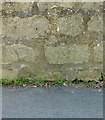
Bench mark, Retford Town Lock
On the boundary wall on the south side of the canal.
Image: © Alan Murray-Rust
Taken: 11 Oct 2015
0.01 miles
8
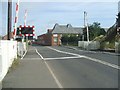
Thrumpton Lane Level Crossing
Looking towards the town centre.
Image: © John M
Taken: 17 Jun 2011
0.02 miles
10
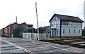
Signal box on Thrumpton Lane, Retford
Image: © Mat Fascione
Taken: 28 May 2016
0.02 miles