IMAGES TAKEN NEAR TO
Carr Road, RETFORD, DN22 6ER
Introduction
This page details the photographs taken nearby to Carr Road, DN22 6ER by members of the Geograph project.
The Geograph project started in 2005 with the aim of publishing, organising and preserving representative images for every square kilometre of Great Britain, Ireland and the Isle of Man.

There are currently over 7.5m images from over14,400 individuals and you can help contribute to the project by visiting https://www.geograph.org.uk
Image Map
Images are licensed for reuse under creativecommons.org/licenses/by-sa/2.0
Notes
- Clicking on the map will re-center to the selected point.
- The higher the marker number, the further away the image location is from the centre of the postcode.
Image Listing (231 Images Found)
Images are licensed for reuse under creativecommons.org/licenses/by-sa/2.0
Image
Details
Distance
1
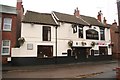
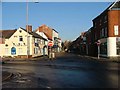
The White Lion
Hostelry on West Street
Image: © Richard Croft
Taken: 7 Jan 2009
0.01 miles
2
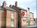
Rum Runner, Retford
Typical red brick buildings in central Retford. These are a cottage and a pub just north of the Town Lock on the Chesterfield Canal.
Image: © Colin Smith
Taken: 28 Aug 2009
0.02 miles
3
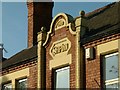
Rum Runner (Ship Inn) ? detail
The old name and date stone survive on the frontage.
Image: © Alan Murray-Rust
Taken: 11 Oct 2015
0.02 miles
4
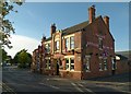
Rum Runner (Ship Inn)
The old name is still prominent on the central pediment. Built 1901, a typical double front public house of the period.
Image: © Alan Murray-Rust
Taken: 11 Oct 2015
0.03 miles
5
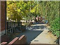
Carolgate Retford
Now pedestrianised, it used to be part of the old A1 road.
Image: © B Hilton
Taken: 11 Dec 2005
0.03 miles
6
Footpath into town from the canal
There is a bench mark http://www.geograph.org.uk/photo/4699349 to the right of the downpipe on the left.
Image: © Alan Murray-Rust
Taken: 11 Oct 2015
0.04 miles
7
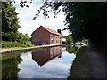
The Chesterfield Canal at Retford Town Lock
The building reflected in the canal appears to be a former warehouse being converted to residential use.
Image: © Graham Hogg
Taken: 6 Jul 2018
0.04 miles
8
Bench mark, canal warehouse
See http://www.geograph.org.uk/photo/4699351 for location.
Image: © Alan Murray-Rust
Taken: 11 Oct 2015
0.05 miles
9
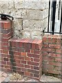
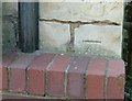
Cut Bench Mark on a Former Canal Warehouse
This mark was nearly lost to brickwork on the side of a ramp to the canalside. See https://www.geograph.org.uk/photo/7172646 for a wider view and https://www.bench-marks.org.uk/bm70936 for details of the mark.
Image: © Brian Westlake
Taken: 5 May 2022
0.05 miles
10
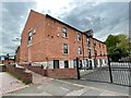
Former Canal Warehouse now Homes
This converted warehouse carries a cut bench mark on the near angle, just avoiding being covered by the newer brickwork at the side of the access ramp. See https://www.geograph.org.uk/photo/7172643 for a close-up and https://www.bench-marks.org.uk/bm70936 for details of the mark.
Image: © Brian Westlake
Taken: 5 May 2022
0.05 miles