IMAGES TAKEN NEAR TO
Birch Close, RETFORD, DN22 0TB
Introduction
This page details the photographs taken nearby to Birch Close, DN22 0TB by members of the Geograph project.
The Geograph project started in 2005 with the aim of publishing, organising and preserving representative images for every square kilometre of Great Britain, Ireland and the Isle of Man.

There are currently over 7.5m images from over14,400 individuals and you can help contribute to the project by visiting https://www.geograph.org.uk
Image Map
Images are licensed for reuse under creativecommons.org/licenses/by-sa/2.0
Notes
- Clicking on the map will re-center to the selected point.
- The higher the marker number, the further away the image location is from the centre of the postcode.
Image Listing (50 Images Found)
Images are licensed for reuse under creativecommons.org/licenses/by-sa/2.0
Image
Details
Distance
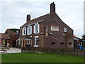
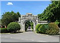
4
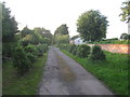
Manor House driveway, Rampton
Rampton Village Hall on the right.
Image: © Jonathan Thacker
Taken: 15 Jul 2012
0.15 miles
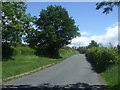
6
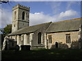
All Saints' church, Rampton, Notts.
Largely Early English church with a Norman font
Image: © Richard Croft
Taken: 27 Sep 2005
0.15 miles
7
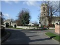
All Saints' Church and Manor Entrance Rampton, Notts
Image: © John Mace
Taken: 15 Jun 2004
0.15 miles
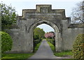
8
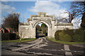
Manor House gateway
Neo-Tudor 19th century gateway to the drive that leads to the Manor House
Image: © Richard Croft
Taken: 20 Feb 2010
0.15 miles
9

Gateway at Rampton
This is the nineteenth century gateway to Rampton Manor House looking towards Treswell Road.
Image: © Jonathan Thacker
Taken: 15 Jul 2012
0.16 miles