IMAGES TAKEN NEAR TO
East Drayton, RETFORD, DN22 0LE
Introduction
This page details the photographs taken nearby to DN22 0LE by members of the Geograph project.
The Geograph project started in 2005 with the aim of publishing, organising and preserving representative images for every square kilometre of Great Britain, Ireland and the Isle of Man.

There are currently over 7.5m images from over14,400 individuals and you can help contribute to the project by visiting https://www.geograph.org.uk
Image Map
Images are licensed for reuse under creativecommons.org/licenses/by-sa/2.0
Notes
- Clicking on the map will re-center to the selected point.
- The higher the marker number, the further away the image location is from the centre of the postcode.
Image Listing (3 Images Found)
Images are licensed for reuse under creativecommons.org/licenses/by-sa/2.0
Image
Details
Distance
1
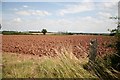
View from Dolegate Road
From the high point of the footpath, across farmland towards Rampton Hospital and Cottam Power Station.
Image: © Richard Croft
Taken: 29 Jul 2006
0.19 miles
2
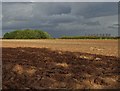
Ploughed field with a view to Cottam Power Station
Image: © Neil Theasby
Taken: 17 Oct 2019
0.23 miles
3
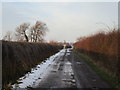
Lane to Hardings Farm
This is a public footpath up to about the limit of this photograph.
Image: © Jonathan Thacker
Taken: 31 Dec 2014
0.25 miles