IMAGES TAKEN NEAR TO
Treswell, RETFORD, DN22 0EW
Introduction
This page details the photographs taken nearby to DN22 0EW by members of the Geograph project.
The Geograph project started in 2005 with the aim of publishing, organising and preserving representative images for every square kilometre of Great Britain, Ireland and the Isle of Man.

There are currently over 7.5m images from over14,400 individuals and you can help contribute to the project by visiting https://www.geograph.org.uk
Image Map
Images are licensed for reuse under creativecommons.org/licenses/by-sa/2.0
Notes
- Clicking on the map will re-center to the selected point.
- The higher the marker number, the further away the image location is from the centre of the postcode.
Image Listing (26 Images Found)
Images are licensed for reuse under creativecommons.org/licenses/by-sa/2.0
Image
Details
Distance
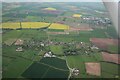
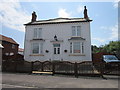
2
Treswell: 2023 (2)
Top right is Rampton Secure Hospital.
Image: © Chris
Taken: 18 May 2023
0.09 miles
3
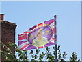
Upside down Union Flag #45
This one is hard to believe, the Queen is the right way up but she has been put on the flag upside down. So to fly the flag the right way round the Queen would be upside down. Seen in the village of Treswell.
Image: © Ian S
Taken: 22 Jul 2012
0.11 miles
4
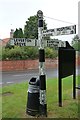
Old Direction Sign - Signpost by Town Street, Treswell
Octagonal finial - 3 arms; Notts CC octagonal concrete, octagonal cast iron finial (NCC) by the UC road, in parish of Treswell (Bassetlaw District), junction of Town Street and Cocking Lane, on verge.
Surveyed
Milestone Society National ID: NT_SK7879
Image: © Milestone Society
Taken: Unknown
0.12 miles
6
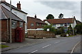
Village street, Treswell
A view along Town street past the telephone box.
Image: © Andrew Hill
Taken: 17 Jul 2010
0.15 miles
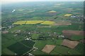
7
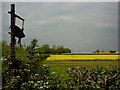
Field and farm sign
At the start of a track just north of the village of Treswell.
Image: © Andrew Hill
Taken: 19 May 2010
0.20 miles
8
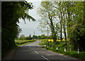
Road leaving Treswell village
View north by the lane towards South Leverton, by the entrance to Treswell church.
Image: © Andrew Hill
Taken: 19 May 2010
0.21 miles
9
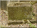
Bench mark, St John the Baptist Church, Treswell
See http://www.geograph.org.uk/photo/4154746 for location.
Image: © Alan Murray-Rust
Taken: 3 Sep 2014
0.21 miles
10
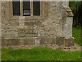
Church of St John the Baptist, Treswell
Early grave slab built into the south wall of the chancel, possibly during the 19th century restoration.
Image: © Alan Murray-Rust
Taken: 3 Sep 2014
0.21 miles