IMAGES TAKEN NEAR TO
DN21 9FG
Introduction
This page details the photographs taken nearby to DN21 9FG by members of the Geograph project.
The Geograph project started in 2005 with the aim of publishing, organising and preserving representative images for every square kilometre of Great Britain, Ireland and the Isle of Man.

There are currently over 7.5m images from over14,400 individuals and you can help contribute to the project by visiting https://www.geograph.org.uk
Image Map (Loading...)


Getting Data...Please wait
Leaflet Map data © OpenStreetMap
Images are licensed for reuse under creativecommons.org/licenses/by-sa/2.0
Notes
- Clicking on the map will re-center to the selected point.
- The higher the marker number, the further away the image location is from the centre of the postcode.
Image Listing (360 Images Found)
Images are licensed for reuse under creativecommons.org/licenses/by-sa/2.0
Image
Details
Distance
2
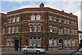
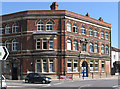
The Gainsborough Heritage Centre, 12 North Street, Gainsborough
Created in 1994, The Heritage Association’s first premises were in the former factory of Marshall’s before finding its current home at the former Old Post Office and telephone exchange building which was built in 1904 and opened in 1905. Cliff Bradley & Sons leased the Old Post Office building to the Association from 2008 to present on a peppercorn rent. The Heritage Centre’s ground floor exhibition room was officially opened to the general public in 2012. The Heritage Centre’s new and enhanced permanent exhibitions based on the ground and 1st floor were officially opened by Gainsborough born actress Julia Deakin at the grand re-opening weekend in September 2016.
Image: © Jo and Steve Turner
Taken: 14 May 2016
0.02 miles
3
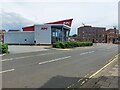
KFC, North Street, Gainsborough
A drive-through KFC restaurant in the centre of Gainsborough.
Image: © Graham Robson
Taken: 9 Jul 2023
0.04 miles
4
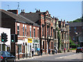
Gainsborough - north side of Spital Terrace
Image: © Dave Bevis
Taken: 26 May 2012
0.04 miles
5
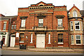
St.John Ambulance Brigade HQ
Late 19th century St.John Ambulance Brigade HQ on Spital Terrace
Image: © Richard Croft
Taken: 31 Oct 2012
0.04 miles
6
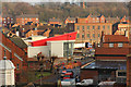
New KFC construction
View from the tower http://www.geograph.org.uk/photo/532030 of Gainsborough Old Hall http://www.geograph.org.uk/photo/3338695 to the construction site of a new KFC on the site of the old Magistrates Court on Roseway
Image: © Richard Croft
Taken: 22 Jan 2014
0.05 miles
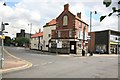
9
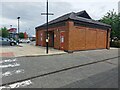
Public toilets, Roseway Car Park, Gainsborough
A brick building containing public conveniences in a Gainsborough town centre car park.
Image: © Graham Robson
Taken: 9 Jul 2023
0.06 miles
10
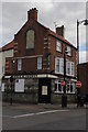
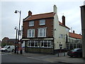
The Horse and Jockey, 42 Church Street, Gainsborough
The building carries a date of 1914 but a 19th century local historian dates it back to 1748. 1824 Parliamentary Papers refer to the establishment on 2nd August 1821 of the Tradesmen's United Friendly Society 'at the house of William Hoyland, the Horse and Jockey, in Gainsborough'. The 1898 OS map shows a public house in this general location probably the rear of the existing building. Shown on this map behind the pub is Lindum Square formerly known as Horse and Jockey Yard according to the heritage assessment. It seems credible therefore the pub was in existence back to 1748 if later re-built. Directory entries include; 1828 William Hoyland; 1835 John Whitlam; 1841 Thomas Martin; 1856 Robert Barnett (& poor rate collector); 1868-1872 Joseph Drury; 1885 William Marsden; 1889-1896 John Leaning; 1901 just 'Horse and Jockey, 38 Church st.'; 1905 Samuel Walker; 1913-1919 Sam Lax (still No.38).
Image: © Jo and Steve Turner
Taken: 14 May 2016
0.06 miles