
IMAGES TAKEN NEAR TO
Plassey Road, GAINSBOROUGH, DN21 5XH
Introduction
This page details the photographs taken nearby to Plassey Road, DN21 5XH by members of the Geograph project.
The Geograph project started in 2005 with the aim of publishing, organising and preserving representative images for every square kilometre of Great Britain, Ireland and the Isle of Man.

There are currently over 7.5m images from over14,400 individuals and you can help contribute to the project by visiting https://www.geograph.org.uk
Image Map
Images are licensed for reuse under creativecommons.org/licenses/by-sa/2.0
Notes
- Clicking on the map will re-center to the selected point.
- The higher the marker number, the further away the image location is from the centre of the postcode.
Image Listing (20 Images Found)
Images are licensed for reuse under creativecommons.org/licenses/by-sa/2.0
Image
Details
Distance
1
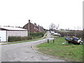
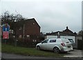
Plassey Road
This community developed out of military buildings surrounding the RAF base here.
Image: © Jonathan Billinger
Taken: 31 Jan 2007
0.02 miles
2
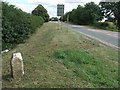
Old Milestone
Old milestone on the A.631 at Hemswell Cliff, Lincolnshire. It would appears that the stone has been moved 4 tenths of a mile west than what it appears marked on older O.S. 1:50:000 maps and now not appearing on any new editions in either the old or new location. For close up view see http://www.geograph.org.uk/photo/3652707
Image: © Keith Evans
Taken: 9 Sep 2013
0.03 miles
3
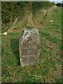
Old Milestone by the A631, Helmswell Cliff, Harpswell
Carved stone post by the A631, in parish of HARPSWELL (WEST LINDSEY District), Hemswell airfield, East of main entrance, by junction with Gibraltar Road, Harpswell, on cut grass verge, at junction, on North side of road. Erected by the Beckford Harbour turnpike trust in the 19th century. Has been moved west of its original position.
Inscription reads:-
: RASEN / 11 / MILES : : HARPSWELL : : GAINSBRO / 9 / MILES :
Milestone Society National ID: LI_GBRS09
Image: © Christine Minto
Taken: 26 Aug 2024
0.05 miles
4
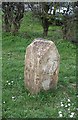
Old Milestone by the A631, Helmswell Cliff, Harpswell
Carved stone post by the A631, in parish of HARPSWELL (WEST LINDSEY District), Hemswell airfield, East of main entrance, by junction with Gibraltar Road, Harpswell, on cut grass verge, at junction, on North side of road. Erected by the Beckford Harbour turnpike trust in the 19th century.
Inscription reads:-
: RASEN / 11 / MILES : : HARPSWELL : : GAINSBRO / 9 / MILES :
Milestone Society National ID: LI_GBRS09
Image: © A Rosevear
Taken: 18 Mar 2012
0.05 miles
5
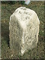
Old Milestone
Old milestone on the A.631 at Hemswell Cliff, Lincolnshire. It would appears that the stone has been moved 4 tenths of a mile west than what it appears marked on older O.S. 1:50:000 maps and now not appearing on any new editions in either the old or new location. For over all view see http://www.geograph.org.uk/photo/3652708
Image: © Keith Evans
Taken: 9 Sep 2013
0.06 miles
9

New housing development, Hemswell Cliff: aerial 2025
Image: © Chris
Taken: 2 Nov 2025
0.11 miles
10
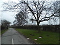
Looking west from Dog Kennel Road, Hemswell Cliff
Image: © Ian S
Taken: 2 Mar 2011
0.12 miles