IMAGES TAKEN NEAR TO
Harpswell, GAINSBOROUGH, DN21 5XA
Introduction
This page details the photographs taken nearby to DN21 5XA by members of the Geograph project.
The Geograph project started in 2005 with the aim of publishing, organising and preserving representative images for every square kilometre of Great Britain, Ireland and the Isle of Man.

There are currently over 7.5m images from over14,400 individuals and you can help contribute to the project by visiting https://www.geograph.org.uk
Image Map
Images are licensed for reuse under creativecommons.org/licenses/by-sa/2.0
Notes
- Clicking on the map will re-center to the selected point.
- The higher the marker number, the further away the image location is from the centre of the postcode.
Image Listing (9 Images Found)
Images are licensed for reuse under creativecommons.org/licenses/by-sa/2.0
Image
Details
Distance
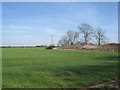
2
At Billyards Farm
Old grain silos.
Image: © Jonathan Thacker
Taken: 27 Mar 2012
0.05 miles
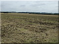
3
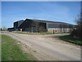
Billyards Farm
The farm occupies the south west corner of Harpswell parish.
Image: © Jonathan Thacker
Taken: 27 Mar 2012
0.05 miles
5
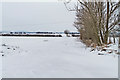
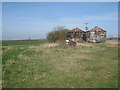
Snow-covered track near Billyards Farm
This farm track off common lane makes its way to Westlands Farm in the next square.
Image: © J.Hannan-Briggs
Taken: 19 Jan 2013
0.09 miles
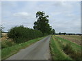
7
View towards Billyards Farm
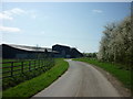
A slight rise (on which Billyards Farm stands) blocks the view of the Lincoln Edge (or Cliff) which is the dominant landscape feature of this area.
Image: © Jonathan Thacker
Taken: 27 Mar 2012
0.12 miles
9
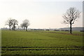
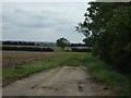
Harpswell Low Fields
Looking west towards Billyards Farm on the left and Harpswell Wood on the right
Image: © Richard Croft
Taken: 28 Jan 2006
0.18 miles