IMAGES TAKEN NEAR TO
Gainsborough Road, GAINSBOROUGH, DN21 5PL
Introduction
This page details the photographs taken nearby to Gainsborough Road, DN21 5PL by members of the Geograph project.
The Geograph project started in 2005 with the aim of publishing, organising and preserving representative images for every square kilometre of Great Britain, Ireland and the Isle of Man.

There are currently over 7.5m images from over14,400 individuals and you can help contribute to the project by visiting https://www.geograph.org.uk
Image Map (Loading...)


Getting Data...Please wait
Leaflet Map data © OpenStreetMap
Images are licensed for reuse under creativecommons.org/licenses/by-sa/2.0
Notes
- Clicking on the map will re-center to the selected point.
- The higher the marker number, the further away the image location is from the centre of the postcode.
Image Listing (7 Images Found)
Images are licensed for reuse under creativecommons.org/licenses/by-sa/2.0
Image
Details
Distance
1
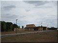
Lea Fields Crematorium
Opened January 2020 and operated by West Lindsey District Council.
Image: © Jonathan Thacker
Taken: 17 May 2020
0.01 miles
2
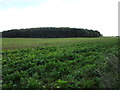
Norbury Hills
The woodland disguises the low hill rising to the east of the River Trent,
Image: © Jonathan Thacker
Taken: 16 Oct 2016
0.12 miles

4
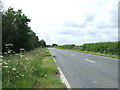
Gainsborough Road (A156)
Heading south towards Lincoln.
Image: © JThomas
Taken: 29 Jun 2013
0.14 miles
5
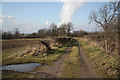
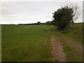
Lea Marshes
Track to Lea Marshes with West Burton power station on the horizon
Image: © Richard Croft
Taken: 20 Feb 2010
0.16 miles
7
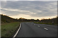
A156 Gainsborough Road
Southbound in fading light on a November afternoon.
Image: © J.Hannan-Briggs
Taken: 13 Nov 2016
0.23 miles