IMAGES TAKEN NEAR TO
Avenue A, GAINSBOROUGH, DN21 5NX
Introduction
This page details the photographs taken nearby to Avenue A, DN21 5NX by members of the Geograph project.
The Geograph project started in 2005 with the aim of publishing, organising and preserving representative images for every square kilometre of Great Britain, Ireland and the Isle of Man.

There are currently over 7.5m images from over14,400 individuals and you can help contribute to the project by visiting https://www.geograph.org.uk
Image Map (Loading...)


Getting Data...Please wait
Leaflet Map data © OpenStreetMap
Images are licensed for reuse under creativecommons.org/licenses/by-sa/2.0
Notes
- Clicking on the map will re-center to the selected point.
- The higher the marker number, the further away the image location is from the centre of the postcode.
Image Listing (74 Images Found)
Images are licensed for reuse under creativecommons.org/licenses/by-sa/2.0
Image
Details
Distance
1
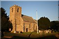
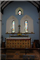
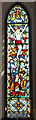
All Saints' church, Upton
Lit by the golden glow of low Autumn sun
Image: © Richard Croft
Taken: 6 Nov 2006
0.05 miles
4
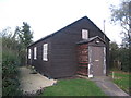
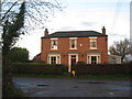
Former Church Hall, Upton
This was also used as the Vicarage during the years of World War Two owing to the peculiar circumstances of the time.
Image: © Jonathan Thacker
Taken: 4 Nov 2011
0.08 miles
5
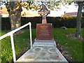
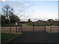
Upton War Memorial
The war memorial at Upton must be relatively new as it does not appear on the Google Streetview photograph from May 2011.
Image: © Marathon
Taken: 29 Sep 2018
0.08 miles