IMAGES TAKEN NEAR TO
Cade Lane, GAINSBOROUGH, DN21 5NN
Introduction
This page details the photographs taken nearby to Cade Lane, DN21 5NN by members of the Geograph project.
The Geograph project started in 2005 with the aim of publishing, organising and preserving representative images for every square kilometre of Great Britain, Ireland and the Isle of Man.

There are currently over 7.5m images from over14,400 individuals and you can help contribute to the project by visiting https://www.geograph.org.uk
Image Map (Loading...)


Getting Data...Please wait
Leaflet Map data © OpenStreetMap
Images are licensed for reuse under creativecommons.org/licenses/by-sa/2.0
Notes
- Clicking on the map will re-center to the selected point.
- The higher the marker number, the further away the image location is from the centre of the postcode.
Image Listing (75 Images Found)
Images are licensed for reuse under creativecommons.org/licenses/by-sa/2.0
Image
Details
Distance
1

Fish and chips in Upton
Something fishy in this flower bed
Image: © Chris Morgan
Taken: 8 May 2018
0.04 miles
3
The Upton Fish & Chip Shop on the High Street
Image: © Ian S
Taken: 13 Jul 2014
0.05 miles
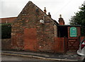
5
Upton Fish and Chip Shop
Open Friday evenings and Saturday midday.
Image: © Jonathan Thacker
Taken: 4 Nov 2011
0.06 miles
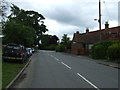
6

Road junction at Upton
The church is just towards the right.
Image: © roger geach
Taken: 5 Mar 2010
0.06 miles
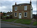
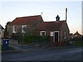
7
The Upton Methodist Church, High Street, Upton
Image: © Ian S
Taken: 13 Jul 2014
0.06 miles
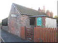
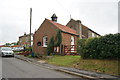
8
Upton Methodist Chapel
On the gable end facing the road is a cut bench mark. See http://www.geograph.org.uk/photo/5245755 for a close-up and http://www.bench-marks.org.uk/bm81288 for details.
Image: © Brian Westlake
Taken: 5 Jan 2017
0.06 miles
9
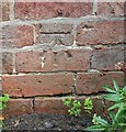
Ordnance Survey Cut Mark
This OS cut mark can be found on the south face of the chapel. It marks a point 23.774m above mean sea level.
Image: © Adrian Dust
Taken: 26 Jul 2017
0.06 miles
10

Cut Mark: Upton Methodist Chapel
On the gable end facing the road is a cut bench mark. See http://www.geograph.org.uk/photo/5245749 for a wider view and http://www.bench-marks.org.uk/bm81288 for details.
Image: © Brian Westlake
Taken: 5 Jan 2017
0.06 miles