IMAGES TAKEN NEAR TO
Lansdall Avenue, GAINSBOROUGH, DN21 5JL
Introduction
This page details the photographs taken nearby to Lansdall Avenue, DN21 5JL by members of the Geograph project.
The Geograph project started in 2005 with the aim of publishing, organising and preserving representative images for every square kilometre of Great Britain, Ireland and the Isle of Man.

There are currently over 7.5m images from over14,400 individuals and you can help contribute to the project by visiting https://www.geograph.org.uk
Image Map
Images are licensed for reuse under creativecommons.org/licenses/by-sa/2.0
Notes
- Clicking on the map will re-center to the selected point.
- The higher the marker number, the further away the image location is from the centre of the postcode.
Image Listing (2 Images Found)
Images are licensed for reuse under creativecommons.org/licenses/by-sa/2.0
Image
Details
Distance
1
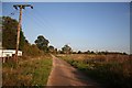
Track to Lea Wood Farm
Lane heading east from Lea Road
Image: © Richard Croft
Taken: 6 Nov 2006
0.23 miles
2
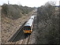
Next stop Gainsborough Lea Road
A train for Lincoln approaches Gainsborough Lea Road station about half a mile distant.
Image: © roger geach
Taken: 5 Mar 2010
0.24 miles