IMAGES TAKEN NEAR TO
Chapel Road, GAINSBOROUGH, DN21 5BP
Introduction
This page details the photographs taken nearby to Chapel Road, DN21 5BP by members of the Geograph project.
The Geograph project started in 2005 with the aim of publishing, organising and preserving representative images for every square kilometre of Great Britain, Ireland and the Isle of Man.

There are currently over 7.5m images from over14,400 individuals and you can help contribute to the project by visiting https://www.geograph.org.uk
Image Map
Images are licensed for reuse under creativecommons.org/licenses/by-sa/2.0
Notes
- Clicking on the map will re-center to the selected point.
- The higher the marker number, the further away the image location is from the centre of the postcode.
Image Listing (52 Images Found)
Images are licensed for reuse under creativecommons.org/licenses/by-sa/2.0
Image
Details
Distance
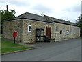
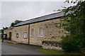
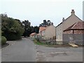
3
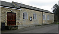
Village Hall
Interesting windows which seem to echo some of the architectural features of Fillingham castle.
Image: © Kate Nicol
Taken: 15 Feb 2009
0.08 miles
4
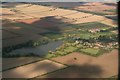
Fillingham and the Cliff: aerial 2017
A good shot of the "Cliff", which runs N and S through and from Image The B1398 "Middle Street" runs along the crest. It runs from south of Lincoln up towards Scunthorpe, through a series of villages with "Cliff" in their name eg. Hemswell Cliff.
See also Image and Image
Image: © Chris
Taken: 19 Sep 2017
0.09 miles
6
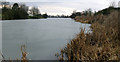
Fillingham Lake
View looking west. This man-made lake forms part of the landscape engineered by the builders of Fillingham Castle. Only the nearest portion of the lake is in this square.
Image: © Kate Nicol
Taken: 15 Feb 2009
0.11 miles
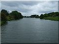
9

Bridge over the lake
The church tower can be seen to the left of the picture. The bridge acts as a bridleway over the lake. View looking South.
Image: © Kate Nicol
Taken: 15 Feb 2009
0.12 miles
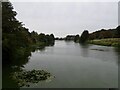
10
Near the Lake, Fillingham
Derelict house on North bank of Fillingham lake. View looking West from public footpath
Image: © Kate Nicol
Taken: 15 Feb 2009
0.14 miles