IMAGES TAKEN NEAR TO
Waddingham, GAINSBOROUGH, DN21 4UP
Introduction
This page details the photographs taken nearby to DN21 4UP by members of the Geograph project.
The Geograph project started in 2005 with the aim of publishing, organising and preserving representative images for every square kilometre of Great Britain, Ireland and the Isle of Man.

There are currently over 7.5m images from over14,400 individuals and you can help contribute to the project by visiting https://www.geograph.org.uk
Image Map
Images are licensed for reuse under creativecommons.org/licenses/by-sa/2.0
Notes
- Clicking on the map will re-center to the selected point.
- The higher the marker number, the further away the image location is from the centre of the postcode.
Image Listing (8 Images Found)
Images are licensed for reuse under creativecommons.org/licenses/by-sa/2.0
Image
Details
Distance
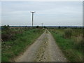
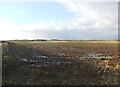
1
Track towards South Carr
It is one of the many tracks named "Green Lane".
Image: © J.Hannan-Briggs
Taken: 30 Aug 2014
0.09 miles
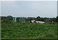
3
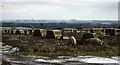
South Carr, Snitterby
Pig farm with view to the Wolds on horizon. View looking East.
Image: © Kate Nicol
Taken: 7 Feb 2009
0.14 miles
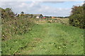
4
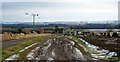
South Carr, Snitterby
Track to South Carr farm. The land drops away to the Ancholme valley here. The Wolds can be seen rising up on the horizon.
Image: © Kate Nicol
Taken: 7 Feb 2009
0.18 miles
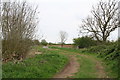
5
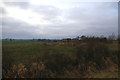
Near Snitterby Carr
Picture taken from the road south of Waddingham, close to the junction with the road to Snitterby, looking East towards a ruined barn.
Image: © David Wright
Taken: 19 Feb 2006
0.19 miles