IMAGES TAKEN NEAR TO
High Street, GAINSBOROUGH, DN21 4SP
Introduction
This page details the photographs taken nearby to High Street, DN21 4SP by members of the Geograph project.
The Geograph project started in 2005 with the aim of publishing, organising and preserving representative images for every square kilometre of Great Britain, Ireland and the Isle of Man.

There are currently over 7.5m images from over14,400 individuals and you can help contribute to the project by visiting https://www.geograph.org.uk
Image Map
Images are licensed for reuse under creativecommons.org/licenses/by-sa/2.0
Notes
- Clicking on the map will re-center to the selected point.
- The higher the marker number, the further away the image location is from the centre of the postcode.
Image Listing (42 Images Found)
Images are licensed for reuse under creativecommons.org/licenses/by-sa/2.0
Image
Details
Distance
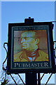
3
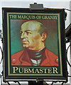
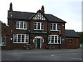
The Sign of The Marquis of Granby, Waddingham
For a photo of this public house see Image It is interesting to compare this representation of the noble Marquis with that on the pub of the name name in Hessle Image
Image: © David Wright
Taken: 29 Apr 2008
0.02 miles
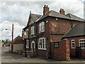
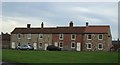
6
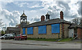
The Old School
This building carries a date of 1830.
Image: © David Wright
Taken: 29 Apr 2008
0.03 miles
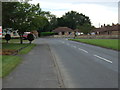
9
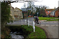
Waddingham
Picture from Clay Lane. The junction is the B1205 Kirton road joining with the Redbourne Road. The stream is Waddingham Beck.
Image: © David Wright
Taken: 19 Feb 2006
0.05 miles