IMAGES TAKEN NEAR TO
Sandbeck Lane, GAINSBOROUGH, DN21 3LN
Introduction
This page details the photographs taken nearby to Sandbeck Lane, DN21 3LN by members of the Geograph project.
The Geograph project started in 2005 with the aim of publishing, organising and preserving representative images for every square kilometre of Great Britain, Ireland and the Isle of Man.

There are currently over 7.5m images from over14,400 individuals and you can help contribute to the project by visiting https://www.geograph.org.uk
Image Map (Loading...)


Getting Data...Please wait
Leaflet Map data © OpenStreetMap
Images are licensed for reuse under creativecommons.org/licenses/by-sa/2.0
Notes
- Clicking on the map will re-center to the selected point.
- The higher the marker number, the further away the image location is from the centre of the postcode.
Image Listing (4 Images Found)
Images are licensed for reuse under creativecommons.org/licenses/by-sa/2.0
Image
Details
Distance
1
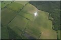
Laughton Common: aerial 2021 (1)
Pinewood Shooting Ground below.
Of interest are the bumps in the centre field, though they may just be patches of tall weeds. The longer mounds may be related to the site's use as a shooting ground.
For detail see Image and Image
Image: © Chris
Taken: 5 Jun 2021
0.17 miles
2
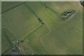
Laughton Common: aerial 2021 (2)
Pinewood Shooting Ground bottom left.
Of interest are the bumps in the centre, though they may just be patches of tall weeds. The longer mounds may be related to the site's use as a shooting ground.
Detail of Image See also Image
Image: © Chris
Taken: 5 Jun 2021
0.20 miles
3
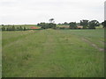
The bridleway to Blyton
Looking towards Blyton Gate with Sandbeck Farm to the right of the bridleway.
Image: © Jonathan Thacker
Taken: 5 Jun 2011
0.24 miles
4
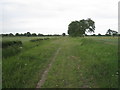
Bridleway to Blyton (2)
Alongside the Great Catchwater Drain.
Image: © Jonathan Thacker
Taken: 5 Jun 2011
0.25 miles