IMAGES TAKEN NEAR TO
The Rookery, GAINSBOROUGH, DN21 3FB
Introduction
This page details the photographs taken nearby to The Rookery, DN21 3FB by members of the Geograph project.
The Geograph project started in 2005 with the aim of publishing, organising and preserving representative images for every square kilometre of Great Britain, Ireland and the Isle of Man.

There are currently over 7.5m images from over14,400 individuals and you can help contribute to the project by visiting https://www.geograph.org.uk
Image Map (Loading...)


Getting Data...Please wait
Leaflet Map data © OpenStreetMap
Images are licensed for reuse under creativecommons.org/licenses/by-sa/2.0
Notes
- Clicking on the map will re-center to the selected point.
- The higher the marker number, the further away the image location is from the centre of the postcode.
Image Listing (11 Images Found)
Images are licensed for reuse under creativecommons.org/licenses/by-sa/2.0
Image
Details
Distance
1
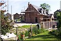
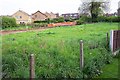
New build in Scotter
This small estate is going up on prime village infill land near the centre of Scotter. The field used to support a few rams while they were 'resting'
Image: © Jonathan Billinger
Taken: 5 Jun 2006
0.16 miles
2
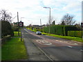
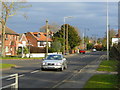
Gainsborough Road, A159, Scotter
Looking south towards Gainsborough.
Image: © Jonathan Billinger
Taken: 28 Dec 2008
0.18 miles
4
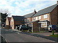
New housing in Scotter 1
These houses were built on a village infill site and finished just before the current credit crunch really began to bite.
Image: © Jonathan Billinger
Taken: 28 Dec 2008
0.21 miles
5

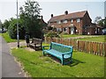
Tulips after the rain
Fine specimens in a garden in Scotter, photographed at 7am on the 1st May 2010
Image: © Jonathan Billinger
Taken: 1 May 2010
0.21 miles
6
Green field site 1
Photo taken in spring 2004 as an access road has been put in to allow development of this field in Scotter. See Image for the same scene two years later.
Image: © Jonathan Billinger
Taken: 12 May 2004
0.22 miles
8
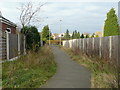
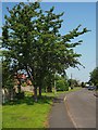
Link path in Scotter
This new right-of-way links new housing to the main road and the village centre.
Image: © Jonathan Billinger
Taken: 28 Dec 2008
0.22 miles
9
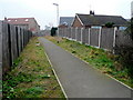
New footpath in Scotter
This links the new housing of Astley Crescent - Image - with the main road.
It covers the trench originally dug to put in services for the new houses.
Image: © Jonathan Billinger
Taken: 19 Mar 2009
0.23 miles
10
Gainsborough Road, A159, Scotter
Looking towards the village centre from the south.
Image: © Jonathan Billinger
Taken: 28 Dec 2008
0.23 miles