IMAGES TAKEN NEAR TO
Hickman Crescent, GAINSBOROUGH, DN21 3BX
Introduction
This page details the photographs taken nearby to Hickman Crescent, DN21 3BX by members of the Geograph project.
The Geograph project started in 2005 with the aim of publishing, organising and preserving representative images for every square kilometre of Great Britain, Ireland and the Isle of Man.

There are currently over 7.5m images from over14,400 individuals and you can help contribute to the project by visiting https://www.geograph.org.uk
Image Map (Loading...)


Getting Data...Please wait
Leaflet Map data © OpenStreetMap
Images are licensed for reuse under creativecommons.org/licenses/by-sa/2.0
Notes
- Clicking on the map will re-center to the selected point.
- The higher the marker number, the further away the image location is from the centre of the postcode.
Image Listing (6 Images Found)
Images are licensed for reuse under creativecommons.org/licenses/by-sa/2.0
Image
Details
Distance
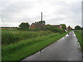
1
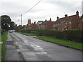
Mill Lane, Morton
The mill dates from 1820 but ceased work in 1918. It has recently been restored from its previous very dilapidated condition.
Image: © Jonathan Thacker
Taken: 6 Jul 2012
0.07 miles
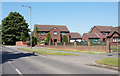
2

Morton Windmill
Former 5-sailed, 5-storey tower mill, built in 1820 but disused by 1918 it succumbed to dereliction until converted for residential use in 1993.
Image: © Richard Croft
Taken: 6 Nov 2006
0.09 miles
4
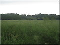
View towards Castle Hills
From Mill Lane, Morton.
Image: © Jonathan Thacker
Taken: 6 Jul 2012
0.22 miles
5
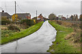
Mill Lane
Towards West Wharton Farm.
Image: © Julian P Guffogg
Taken: 21 Nov 2016
0.24 miles
6
Mill Lane, Morton (2)
Looking towards West Wharton.
Image: © Jonathan Thacker
Taken: 6 Jul 2012
0.25 miles