IMAGES TAKEN NEAR TO
Maple Close, GAINSBOROUGH, DN21 2UA
Introduction
This page details the photographs taken nearby to Maple Close, DN21 2UA by members of the Geograph project.
The Geograph project started in 2005 with the aim of publishing, organising and preserving representative images for every square kilometre of Great Britain, Ireland and the Isle of Man.

There are currently over 7.5m images from over14,400 individuals and you can help contribute to the project by visiting https://www.geograph.org.uk
Image Map
Images are licensed for reuse under creativecommons.org/licenses/by-sa/2.0
Notes
- Clicking on the map will re-center to the selected point.
- The higher the marker number, the further away the image location is from the centre of the postcode.
Image Listing (30 Images Found)
Images are licensed for reuse under creativecommons.org/licenses/by-sa/2.0
Image
Details
Distance
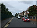
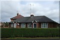
3
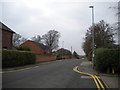
North Warren Road, Gainsborough
Looking towards the River Trent.
Image: © Richard Vince
Taken: 13 Jan 2018
0.12 miles
5
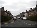
Burns Street, Gainsborough
Seen from North Warren Road.
Image: © Richard Vince
Taken: 13 Jan 2018
0.13 miles
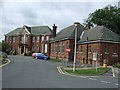
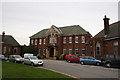
8
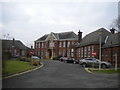
John Coupland Hospital, Gainsborough
Home to a minor injury unit that is not open 24 hours.
Image: © Richard Vince
Taken: 13 Jan 2018
0.14 miles