IMAGES TAKEN NEAR TO
Fillingham Close, GAINSBOROUGH, DN21 1YX
Introduction
This page details the photographs taken nearby to Fillingham Close, DN21 1YX by members of the Geograph project.
The Geograph project started in 2005 with the aim of publishing, organising and preserving representative images for every square kilometre of Great Britain, Ireland and the Isle of Man.

There are currently over 7.5m images from over14,400 individuals and you can help contribute to the project by visiting https://www.geograph.org.uk
Image Map (Loading...)


Getting Data...Please wait
Leaflet Map data © OpenStreetMap
Images are licensed for reuse under creativecommons.org/licenses/by-sa/2.0
Notes
- Clicking on the map will re-center to the selected point.
- The higher the marker number, the further away the image location is from the centre of the postcode.
Image Listing (12 Images Found)
Images are licensed for reuse under creativecommons.org/licenses/by-sa/2.0
Image
Details
Distance
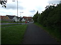
1
Walkway north of Park Springs School, Gainsborough
Image: © Chris Morgan
Taken: 8 May 2018
0.10 miles
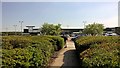
2
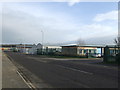
Industrial units on the outskirts of Gainsborough
Image: © Jonathan Billinger
Taken: 31 Jan 2007
0.13 miles

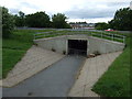
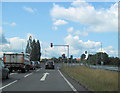
5
Waiting for the lights to change entering Gainsborough
Image: © Steve Fareham
Taken: 16 May 2014
0.15 miles
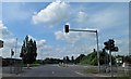
6
Traffic lights at Heapham Road junction with A631
Image: © John Firth
Taken: 11 Jun 2011
0.15 miles
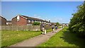
7
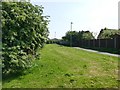
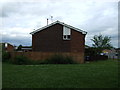
Footpath and green space
In a housing area off Park Springs Road
Image: © Graham Hogg
Taken: 8 May 2018
0.15 miles