IMAGES TAKEN NEAR TO
Ravendale Road, GAINSBOROUGH, DN21 1XD
Introduction
This page details the photographs taken nearby to Ravendale Road, DN21 1XD by members of the Geograph project.
The Geograph project started in 2005 with the aim of publishing, organising and preserving representative images for every square kilometre of Great Britain, Ireland and the Isle of Man.

There are currently over 7.5m images from over14,400 individuals and you can help contribute to the project by visiting https://www.geograph.org.uk
Image Map (Loading...)


Getting Data...Please wait
Leaflet Map data © OpenStreetMap
Images are licensed for reuse under creativecommons.org/licenses/by-sa/2.0
Notes
- Clicking on the map will re-center to the selected point.
- The higher the marker number, the further away the image location is from the centre of the postcode.
Image Listing (9 Images Found)
Images are licensed for reuse under creativecommons.org/licenses/by-sa/2.0
Image
Details
Distance
1
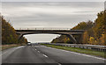
Bridge over the A631, Gainsborough
Middlefield Lane road bridge over the Thorndike way.
Image: © J.Hannan-Briggs
Taken: 13 Nov 2016
0.08 miles
2
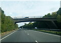
A631 Thorndyke Way passing under Middlefield Lane
Image: © Colin Pyle
Taken: 10 Oct 2021
0.10 miles
3
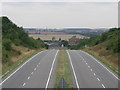
Lonely Biker
A few seconds earlier and this section of the A631 was full of cars. At this point in time only a single motorbike was climbing the hill out of the Trent valley.
Image: © Michael Patterson
Taken: 4 Aug 2006
0.11 miles
4
Looking towards Gainsborough
Taken from the bridge that spans the A631 looking towards the Town.
Image: © roger geach
Taken: 19 Mar 2010
0.14 miles
5
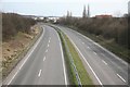
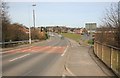
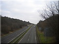
Quiet on the Gainsborough Road
Looking at the A631 away from Gainsborough
Image: © roger geach
Taken: 19 Mar 2010
0.17 miles
6
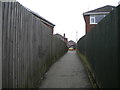
Footpath to Enderby Crescent, Gainsborough
Sneaking between the houses from an open space with playground.
Image: © Richard Vince
Taken: 13 Jan 2018
0.17 miles
7
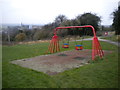
Swings behind Enderby Crescent, Gainsborough
In a fairly small open space overlooking the town centre.
Image: © Richard Vince
Taken: 13 Jan 2018
0.19 miles
8
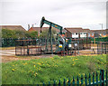
Nodding Donkey Oil/Gas Extraction
BP oil/gas extraction site, at junction of Middlefield Lane and Park Springs Road, Gainsborough. Over the years some of the pumps have been removed.
The site is best viewed from a footpath to the south of the area.
Lincolnshire C.C. provided the following information under the FoI - Freedom of Information Act-
Planning permission for the oil site was granted on 26/5/1959
The developer was BP Exploration Co Ltd
The landowner is West Lindsey District Council and the site is operated by IGas Energy PLC.
Image: © Chris Coleman
Taken: Unknown
0.22 miles
9
Thorndike Way, Gainsborough
The A631 towards Market Rasen and Louth, seen from the footbridge alongside the railway bridge just south east of Gainsborough town centre.
Image: © Richard Vince
Taken: 13 Jan 2018
0.25 miles