IMAGES TAKEN NEAR TO
Dunstall Walk, GAINSBOROUGH, DN21 1UG
Introduction
This page details the photographs taken nearby to Dunstall Walk, DN21 1UG by members of the Geograph project.
The Geograph project started in 2005 with the aim of publishing, organising and preserving representative images for every square kilometre of Great Britain, Ireland and the Isle of Man.

There are currently over 7.5m images from over14,400 individuals and you can help contribute to the project by visiting https://www.geograph.org.uk
Image Map
Images are licensed for reuse under creativecommons.org/licenses/by-sa/2.0
Notes
- Clicking on the map will re-center to the selected point.
- The higher the marker number, the further away the image location is from the centre of the postcode.
Image Listing (8 Images Found)
Images are licensed for reuse under creativecommons.org/licenses/by-sa/2.0
Image
Details
Distance
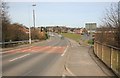
1
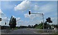
Waiting for the lights to change entering Gainsborough
Image: © Steve Fareham
Taken: 16 May 2014
0.12 miles

3
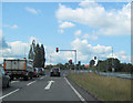
Traffic lights at Heapham Road junction with A631
Image: © John Firth
Taken: 11 Jun 2011
0.13 miles
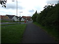
7
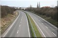
Quiet on the Gainsborough Road
Looking at the A631 away from Gainsborough
Image: © roger geach
Taken: 19 Mar 2010
0.18 miles
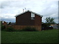
8
Looking towards Gainsborough
Taken from the bridge that spans the A631 looking towards the Town.
Image: © roger geach
Taken: 19 Mar 2010
0.21 miles