IMAGES TAKEN NEAR TO
Old School Close, DN21 1RA
Introduction
This page details the photographs taken nearby to Old School Close, DN21 1RA by members of the Geograph project.
The Geograph project started in 2005 with the aim of publishing, organising and preserving representative images for every square kilometre of Great Britain, Ireland and the Isle of Man.

There are currently over 7.5m images from over14,400 individuals and you can help contribute to the project by visiting https://www.geograph.org.uk
Image Map (Loading...)


Getting Data...Please wait
Leaflet Map data © OpenStreetMap
Images are licensed for reuse under creativecommons.org/licenses/by-sa/2.0
Notes
- Clicking on the map will re-center to the selected point.
- The higher the marker number, the further away the image location is from the centre of the postcode.
Image Listing (4 Images Found)
Images are licensed for reuse under creativecommons.org/licenses/by-sa/2.0
Image
Details
Distance
1
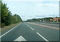
A631 Thorndike Way at The Lincolnshire Otter
Image: © Colin Pyle
Taken: 10 Oct 2021
0.13 miles
2
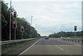
White's Wood Lane junction with A631
Looking East
Image: © John Firth
Taken: 12 Jun 2012
0.13 miles
3
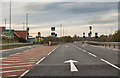
A631 exit to Somerby Park
Turn off for Somerby Park, a relatively new Industrial Estate. On the extreme left is the Lincolnshire Otter Pub.
The traffic lights are those seen in Image
Image: © J.Hannan-Briggs
Taken: 13 Nov 2016
0.15 miles
4
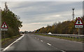
A631 Thorndike Way
Traffic lights in 400 yards. Approaching Gainsborough.
Image: © J.Hannan-Briggs
Taken: 13 Nov 2016
0.23 miles