IMAGES TAKEN NEAR TO
Carr Lane, GAINSBOROUGH, DN21 1LG
Introduction
This page details the photographs taken nearby to Carr Lane, DN21 1LG by members of the Geograph project.
The Geograph project started in 2005 with the aim of publishing, organising and preserving representative images for every square kilometre of Great Britain, Ireland and the Isle of Man.

There are currently over 7.5m images from over14,400 individuals and you can help contribute to the project by visiting https://www.geograph.org.uk
Image Map (Loading...)


Getting Data...Please wait
Leaflet Map data © OpenStreetMap
Images are licensed for reuse under creativecommons.org/licenses/by-sa/2.0
Notes
- Clicking on the map will re-center to the selected point.
- The higher the marker number, the further away the image location is from the centre of the postcode.
Image Listing (24 Images Found)
Images are licensed for reuse under creativecommons.org/licenses/by-sa/2.0
Image
Details
Distance
1
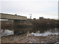
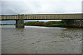
Trent bridge and Trent East Junction signals
Semaphore signals are still in use at Trent East Junction. The main line is still the old Manchester, Sheffield and Lincolnshire route to Grimsby though more traffic uses the Great Northern and Great Eastern Joint Line to Lincoln.
Image: © Jonathan Thacker
Taken: 18 Dec 2010
0.03 miles


4
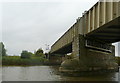
Gainsborough - railway crossing of River Trent
Image: © Dave Bevis
Taken: 17 Apr 2010
0.08 miles
6
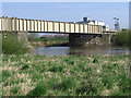
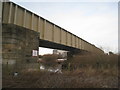
Trent Junction railway bridge
There are two main arches, both navigable, so we took the right-hand one in case there was any downstream traffic. The railway crosses the river between Trent West Junction and Trent East Junction, for which the semaphore signals can be seen.
Image: © Graham Horn
Taken: 23 Sep 2012
0.09 miles
7
Trent Junction railway bridge
There are two main arches, both navigable, so we took the right-hand one in case there was any downstream traffic. (Yes, I am looking back!) The railway crosses the river between Trent West Junction and Trent East Junction.
Image: © Graham Horn
Taken: 23 Sep 2012
0.10 miles
9
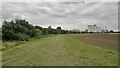
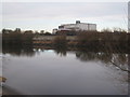
Grain silos beside the River Trent
With West Burton oil fired power station behind. On the Trent Valley Way.
Image: © Chris Morgan
Taken: 3 Sep 2013
0.13 miles
10
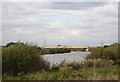
Gainsborough Trent Junction Railway Bridge
The Manchester, Sheffield and Lincolnshire Railway, later part of the Great Central, built this bridge en route to Grimsby and Sheffield. The bridge was shared with the line from Lincoln to Doncaster, part of the Great Northern Railway, which crossed the MS&LR at this river bridge. However, the MS&LR exercised its rights by forcing the Great Northern lines to approach either side of the entrance to the bridge by means of a dog-leg, causing GN trains to cross more slowly, to avoid damaging 'their bridge'.
The River Trent is tidal to this point, and upstream to Newark. Tidal waves, called aegres or aegirs, spectacular before channel deepening following locally disastrous 1947 floods, are associated with the highest tides in spring and autumn.
Image: © Chris Coleman
Taken: 4 Oct 2006
0.13 miles