IMAGES TAKEN NEAR TO
Lindrick Drive, GAINSBOROUGH, DN21 1FY
Introduction
This page details the photographs taken nearby to Lindrick Drive, DN21 1FY by members of the Geograph project.
The Geograph project started in 2005 with the aim of publishing, organising and preserving representative images for every square kilometre of Great Britain, Ireland and the Isle of Man.

There are currently over 7.5m images from over14,400 individuals and you can help contribute to the project by visiting https://www.geograph.org.uk
Image Map (Loading...)


Getting Data...Please wait
Leaflet Map data © OpenStreetMap
Images are licensed for reuse under creativecommons.org/licenses/by-sa/2.0
Notes
- Clicking on the map will re-center to the selected point.
- The higher the marker number, the further away the image location is from the centre of the postcode.
Image Listing (8 Images Found)
Images are licensed for reuse under creativecommons.org/licenses/by-sa/2.0
Image
Details
Distance
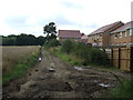
4
Corporate Skip
Even the skip on this Barratt development has to be in corporate orange.
Image: © Michael Patterson
Taken: 4 Aug 2006
0.10 miles
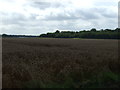
5
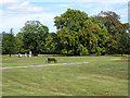
Thonock Park golf course
Former Thonock parkland, now one of the Gainsborough Golf Club courses
Image: © Richard Croft
Taken: 24 Aug 2011
0.10 miles
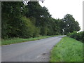
6
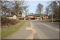
Gainsborough Golf Club
The entrance is right opposite this road junction.
Image: © roger geach
Taken: 19 Mar 2010
0.11 miles
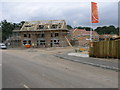
7
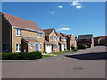
Hoylake Close
New development at The Belt
Image: © Richard Croft
Taken: 24 Aug 2011
0.13 miles
8
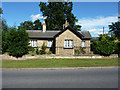
Thonock lodge
Former lodge for Thonock Park, now by the entrance to Gainsborough Golf Club
Image: © Richard Croft
Taken: 24 Aug 2011
0.14 miles