IMAGES TAKEN NEAR TO
Kettleby, BRIGG, DN20 9HN
Introduction
This page details the photographs taken nearby to DN20 9HN by members of the Geograph project.
The Geograph project started in 2005 with the aim of publishing, organising and preserving representative images for every square kilometre of Great Britain, Ireland and the Isle of Man.

There are currently over 7.5m images from over14,400 individuals and you can help contribute to the project by visiting https://www.geograph.org.uk
Image Map (Loading...)


Getting Data...Please wait
Leaflet Map data © OpenStreetMap
Images are licensed for reuse under creativecommons.org/licenses/by-sa/2.0
Notes
- Clicking on the map will re-center to the selected point.
- The higher the marker number, the further away the image location is from the centre of the postcode.
Image Listing (5 Images Found)
Images are licensed for reuse under creativecommons.org/licenses/by-sa/2.0
Image
Details
Distance
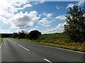
1
Near Kettleby Covert
Picture taken looking East along the A1084 towards the junction with the B1434 (the right hand turning). The wood on the left is Kettleby Covert.
Image: © David Wright
Taken: 5 Jun 2006
0.04 miles
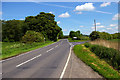
2
Looking towards Howsham Barff Wood
Picture taken from the bridge carrying the A1084 over Kettleby Beck. Priory Farm is on the left and Howsham Barff Wood is in the distance.
Image: © David Wright
Taken: 5 Jun 2006
0.13 miles
3
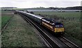
Charter train to Immingham
A special charter train from London Kings Cross to visit the dock railways around Immingham is seen approaching Barnetby. Behind the train farm buildings dominate the view on rather a cloudy day.
Image: © roger geach
Taken: 11 Mar 2000
0.14 miles