IMAGES TAKEN NEAR TO
Kettleby, BRIGG, DN20 9HG
Introduction
This page details the photographs taken nearby to DN20 9HG by members of the Geograph project.
The Geograph project started in 2005 with the aim of publishing, organising and preserving representative images for every square kilometre of Great Britain, Ireland and the Isle of Man.

There are currently over 7.5m images from over14,400 individuals and you can help contribute to the project by visiting https://www.geograph.org.uk
Image Map (Loading...)


Getting Data...Please wait
Leaflet Map data © OpenStreetMap
Images are licensed for reuse under creativecommons.org/licenses/by-sa/2.0
Notes
- Clicking on the map will re-center to the selected point.
- The higher the marker number, the further away the image location is from the centre of the postcode.
Image Listing (6 Images Found)
Images are licensed for reuse under creativecommons.org/licenses/by-sa/2.0
Image
Details
Distance
2
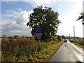
Kettleby Lane
The house on the corner is by the driveway to Kettleby House.
Image: © Chris
Taken: 15 Feb 2014
0.18 miles
3
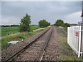
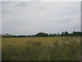
The line towards Barnetby
The former main line of the Manchester, Sheffield and Lincolnshire railway now reduced to a single track and heavily used for freight traffic but only seeing three return passenger journeys on a Saturday only.
Image: © Jonathan Thacker
Taken: 6 Jul 2011
0.22 miles
4
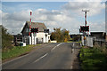
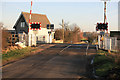
Kettleby crossing
Level crossing on Kettleby Lane
Image: © Richard Croft
Taken: 28 Oct 2010
0.24 miles