IMAGES TAKEN NEAR TO
Melton Road, BRIGG, DN20 8SL
Introduction
This page details the photographs taken nearby to Melton Road, DN20 8SL by members of the Geograph project.
The Geograph project started in 2005 with the aim of publishing, organising and preserving representative images for every square kilometre of Great Britain, Ireland and the Isle of Man.

There are currently over 7.5m images from over14,400 individuals and you can help contribute to the project by visiting https://www.geograph.org.uk
Image Map
Images are licensed for reuse under creativecommons.org/licenses/by-sa/2.0
Notes
- Clicking on the map will re-center to the selected point.
- The higher the marker number, the further away the image location is from the centre of the postcode.
Image Listing (68 Images Found)
Images are licensed for reuse under creativecommons.org/licenses/by-sa/2.0
Image
Details
Distance
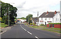
3
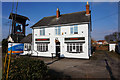
Black Horse, Wrawby
Yet another ex-pub awaiting a new future - will it get a new lease of licensed life?
Image: © Chris Morgan
Taken: 17 Sep 2019
0.03 miles
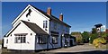
4
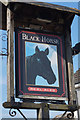
Black Horse, Melton Road, Wrawby
http://www.geograph.org.uk/photo/5715917
Image: © Ian S
Taken: 21 Mar 2018
0.03 miles
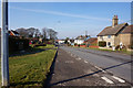
5
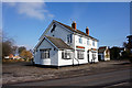
Black Horse, Melton Road, Wrawby
http://www.geograph.org.uk/photo/5715915
Image: © Ian S
Taken: 21 Mar 2018
0.03 miles
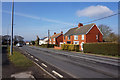
7
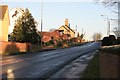
Wrawby village the Black Horse pub on the left
Image: © roger geach
Taken: 16 Jan 2012
0.04 miles
8
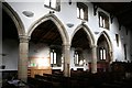
North Arcade
Lofty late 13th century north arcade with octagonal piers and double-chamfered arches in St.Mary's church
Image: © Richard Croft
Taken: 8 Feb 2008
0.05 miles
9
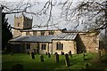
St.Mary's church
St.Mary's has a 13th century tower and N arcade
Image: © Richard Croft
Taken: 8 Feb 2008
0.05 miles