IMAGES TAKEN NEAR TO
Chapel Lane, BRIGG, DN20 8SB
Introduction
This page details the photographs taken nearby to Chapel Lane, DN20 8SB by members of the Geograph project.
The Geograph project started in 2005 with the aim of publishing, organising and preserving representative images for every square kilometre of Great Britain, Ireland and the Isle of Man.

There are currently over 7.5m images from over14,400 individuals and you can help contribute to the project by visiting https://www.geograph.org.uk
Image Map
Images are licensed for reuse under creativecommons.org/licenses/by-sa/2.0
Notes
- Clicking on the map will re-center to the selected point.
- The higher the marker number, the further away the image location is from the centre of the postcode.
Image Listing (48 Images Found)
Images are licensed for reuse under creativecommons.org/licenses/by-sa/2.0
Image
Details
Distance
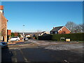
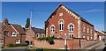
1

Chapel Lane, Wrawby
Chapel Lane, Wrawby, North Lincolnshire
Image: © David Wright
Taken: 31 Jan 2006
0.02 miles
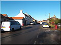
3
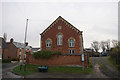
The Old Chapel on Tunnel Road, Wrawby
Dated 1885.
Image: © Ian S
Taken: 21 Nov 2018
0.04 miles
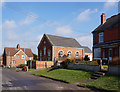
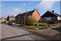
5
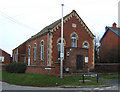
The Old Chapel, Wrawby
Old Chapel situated on the corner of Chapel Lane and Vicarage Road, Wrawby, North Lincolnshire.
Image: © David Wright
Taken: 31 Jan 2006
0.04 miles