IMAGES TAKEN NEAR TO
Brigg Road, BRIGG, DN20 8RQ
Introduction
This page details the photographs taken nearby to Brigg Road, DN20 8RQ by members of the Geograph project.
The Geograph project started in 2005 with the aim of publishing, organising and preserving representative images for every square kilometre of Great Britain, Ireland and the Isle of Man.

There are currently over 7.5m images from over14,400 individuals and you can help contribute to the project by visiting https://www.geograph.org.uk
Image Map (Loading...)


Getting Data...Please wait
Leaflet Map data © OpenStreetMap
Images are licensed for reuse under creativecommons.org/licenses/by-sa/2.0
Notes
- Clicking on the map will re-center to the selected point.
- The higher the marker number, the further away the image location is from the centre of the postcode.
Image Listing (17 Images Found)
Images are licensed for reuse under creativecommons.org/licenses/by-sa/2.0
Image
Details
Distance
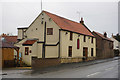
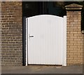
3
Wrawby, Brigg Road, "Hillrise"
There is a cut bench mark to the left of the gate. See http://www.geograph.org.uk/photo/5550979 for a closer view and http://www.bench-marks.org.uk/bm88805 for details.
Image: © Brian Westlake
Taken: 22 Sep 2017
0.07 miles
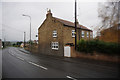
4
Cut Mark: Wrawby, Brigg Road, "Hillrise"
Cut bench mark to the left of the gate. See http://www.geograph.org.uk/photo/5550981 for a wider view and http://www.bench-marks.org.uk/bm88805 for details.
Image: © Brian Westlake
Taken: 22 Sep 2017
0.07 miles
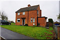
5
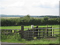
Horses do bite !
And they kick too !
Image: © Jonathan Thacker
Taken: 6 Jul 2011
0.10 miles