IMAGES TAKEN NEAR TO
School Court, BRIGG, DN20 8JW
Introduction
This page details the photographs taken nearby to School Court, DN20 8JW by members of the Geograph project.
The Geograph project started in 2005 with the aim of publishing, organising and preserving representative images for every square kilometre of Great Britain, Ireland and the Isle of Man.

There are currently over 7.5m images from over14,400 individuals and you can help contribute to the project by visiting https://www.geograph.org.uk
Image Map (Loading...)


Getting Data...Please wait
Leaflet Map data © OpenStreetMap
Images are licensed for reuse under creativecommons.org/licenses/by-sa/2.0
Notes
- Clicking on the map will re-center to the selected point.
- The higher the marker number, the further away the image location is from the centre of the postcode.
Image Listing (376 Images Found)
Images are licensed for reuse under creativecommons.org/licenses/by-sa/2.0
Image
Details
Distance
2
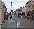
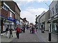
Wrawby Street, Brigg
Friday afternoon on Wrawby Street and its starting to rain.
Image: © David Wright
Taken: 22 Jun 2007
0.01 miles
3
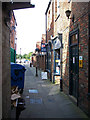
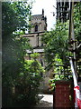
Morleys Yard, Brigg
This alley runs north west from Wrawby Street.
Image: © David Wright
Taken: 18 Jan 2008
0.01 miles
4
The Deli Diner, Brigg
Restaurant on Wrawby Street.
Image: © David Wright
Taken: 6 Jul 2007
0.02 miles
5
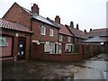
Courtyard houses, Brigg
On the north side of Wrawby Street.
Image: © Christine Johnstone
Taken: 29 Dec 2012
0.02 miles
6
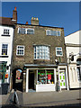
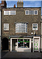
Oxfam book shop
Dedicated charity bookshop in a grade II listed, early 19th century shop on Wrawby Street
Image: © Richard Croft
Taken: 18 Apr 2011
0.02 miles
10
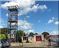
Brigg Fire Station
Humberside Fire Service - Brigg Fire Station, Old Courts Road.
Image: © David Wright
Taken: 1 Sep 2006
0.02 miles