IMAGES TAKEN NEAR TO
Maltkiln Lane, BRIGG, DN20 0RH
Introduction
This page details the photographs taken nearby to Maltkiln Lane, DN20 0RH by members of the Geograph project.
The Geograph project started in 2005 with the aim of publishing, organising and preserving representative images for every square kilometre of Great Britain, Ireland and the Isle of Man.

There are currently over 7.5m images from over14,400 individuals and you can help contribute to the project by visiting https://www.geograph.org.uk
Image Map
Images are licensed for reuse under creativecommons.org/licenses/by-sa/2.0
Notes
- Clicking on the map will re-center to the selected point.
- The higher the marker number, the further away the image location is from the centre of the postcode.
Image Listing (48 Images Found)
Images are licensed for reuse under creativecommons.org/licenses/by-sa/2.0
Image
Details
Distance
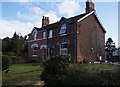
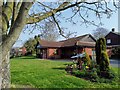
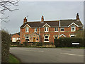
4
Holme Farm Residential Home
Church Street, Elsham.
Image: © Ian S
Taken: 31 Jan 2018
0.07 miles
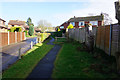
5
Elsham Village Hall
The RAF Elsham Wolds Bomber Command connection reflected throughout the village
Image: © Chris Morgan
Taken: 18 Apr 2019
0.07 miles
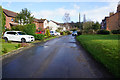
9
Chapel Lane, Elsham
At the junction with Maltkiln Lane in the centre of the village.
Image: © Paul Harrop
Taken: 19 Mar 2020
0.09 miles
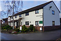
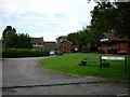
10
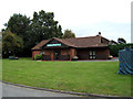
Elsham Village Hall
Elsham Village Hall, Chapel Lane, Elsham, North Lincolnshire.
Image: © David Wright
Taken: 4 Oct 2005
0.10 miles